The Cameron Park Design Review Committee gets its first look at a proposed Mc Donald’s restaurant, along with an ARCO AM/PM gas station & convenience store, and a Quick Quack Car Wash, as a new phase of the Green Valley Station shopping center, near the Grocery Outlet store on the south side of Green Valley Road between Cambridge Drive and Cameron Park Drive.
The Cameron Park DRC will take an initial look at the Pre Applications for the proposed development at their scheduled July 22, 2024 meeting. Pre application PA24-0001 for all three developments was submitted January 31, 2024.
Both the Mc Donald’s and the ARCO AM/PM projects are indicated to operate 24 hours a day.
Project Parking
The Mc Donald’s project specifies that it will provide 22 parking stalls, with 4 for EV charging – with one for an EV Van, and 2 Accessible stalls. El Dorado County Zoning Ordinance indicates that based on floor space of the Quick Serve facility, that the parking requirements should be 17 total stalls – 4 EV, and 2 Accessible.
The ARCO AM/PM will provide 26 parking stalls (12 fueling, 4 EV, and 10 standard stalls). El Dorado County Zoning Ordinance indicates that based on floor space the ARCO AM/PM project is required to provide 20 parking stalls.
The Quick Quack Car Wash will provide 54 parking stalls – 30 wash stacking lane spots, 3 standard parking stalls, and 21 vacuum parking stalls.
Cameron Park Design Review Meeting July 22, 2024 6:30PM
The Cameron Park DRC meeting is scheduled for July 22 at 6:30PM in person at the Shingle Springs Cameron Park Chamber of Commerce, 4095 Cameron Park Drive Cameron Park, CA 95682 OR Live Streamed via zoom https://edcgov-us.zoom.us/j/96425149671
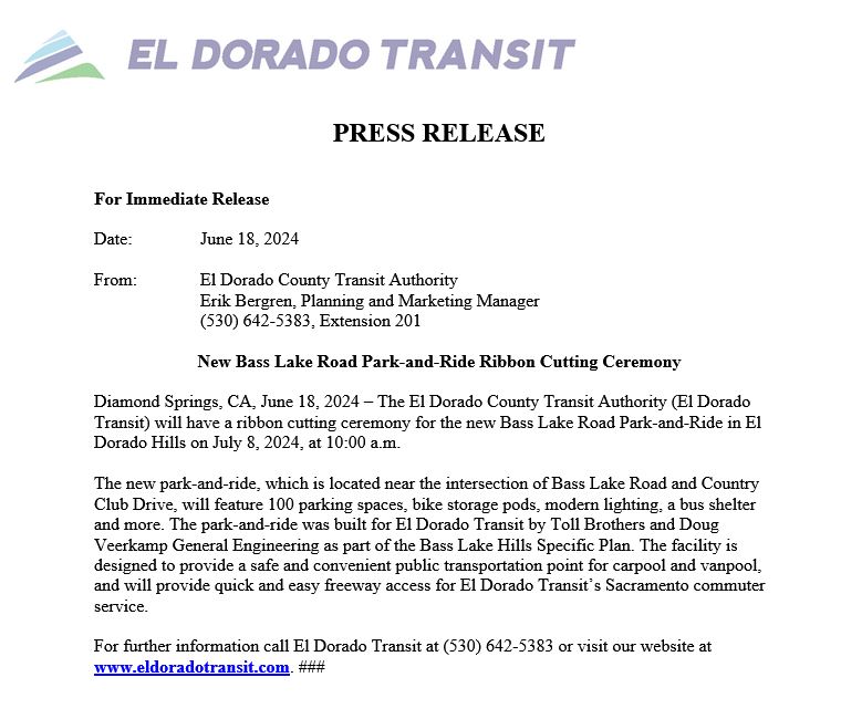
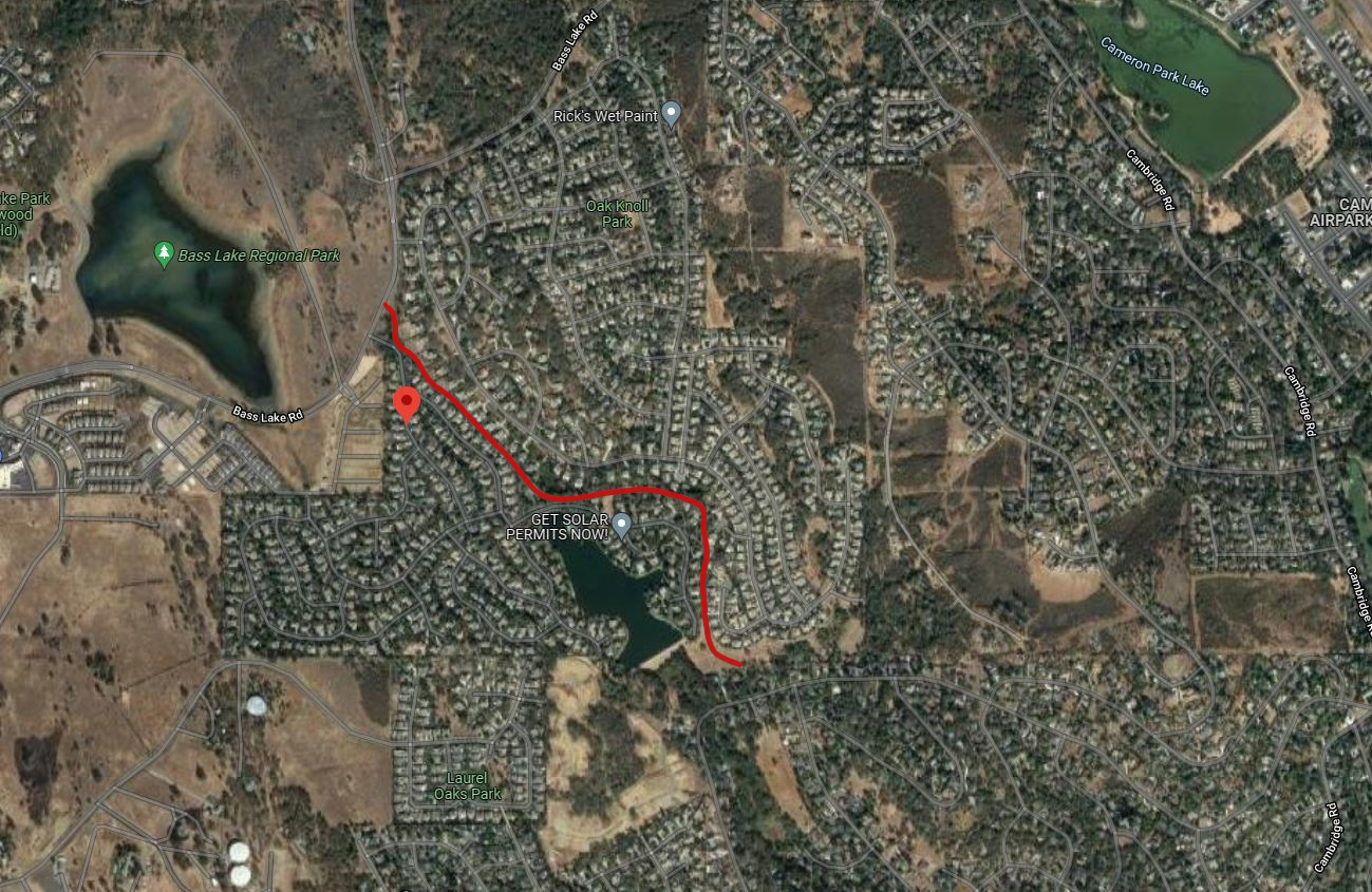
100 Space Park & Ride Lot Required As Condition of Approval of the 90 home Bass Lake North project.
El Dorado Transit has scheduled a ribbon cutting ceremony for July 8th at 10am to celebrate the opening of the 100 parking space Bass Lake Road Park & Ride, located at the south west corner of Bass Lake Road-Country Club Dr intersection, on Old Bass Lake Road.
The park & ride lot will officially open for service on Monday July 15th. All commuter stops at Cambridge Park & Ride will move to Bass Lake Road Park & Ride.
The park & ride lot was an element of the 1996/2016 Bass Lake Hills Specific Plan. The entitlements granted to the 2017 approved 90 home Bass Lake North residential project in the Bass Lake Hills Specific Plan required as a condition of approval the construction of the first 100 parking spaces of what was intended to eventually be a 200 parking space facility. The Bass Lake North project is now known as the Toll Brothers’ Hidden Ridge development.
The park & ride lot is expected to be used for carpool and vanpool riders, as well as for El Dorado Transit’s Sacramento Commuter Service. It is expected to lessen the demand at the Town Center Park & Ride lot in El Dorado Hills, which is over-impacted.
The park & ride lot is also available for parking to access the future trail system in the Bass Lake Hills Specific Plan area, with connectivity to trails in the Serrano area, as well as bike trails east into Cameron Park.
It is expected that the El Dorado County Household Hazardous Waste collection events that have been held at El Dorado Hills Fire Station 86 on Bass Lake Road will now be conducted at the Bass Lake Road Park and Ride facility.
For more information, contact El Dorado Transit at 530 642-5383, or online at eldoradotransit.com
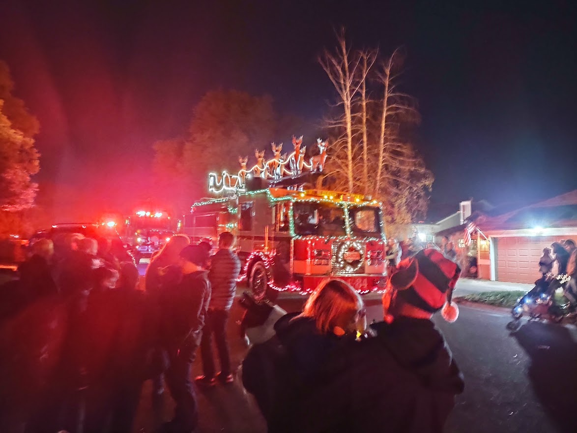
Santa Arrives in the Bass Lake Area at 6PM on Thursday December 8th!
Bass Lake Area Neighbors, are you ready for Santa’s HOLIDAY HEROES visit this Thursday December 8th? Santa and his El Dorado Hills Fire Department Elves will be collecting unwrapped toys, non-perishable food and letters to Santa at each of the planned Santa Stops. Toys collected will be donated to the Shriners’ Hospital for Children of Northern California, and non-perishable food donations will go to the Foodbank of El Dorado County. Last year Santa and his EDH Fire Dept Elves collected 7,800 toys and 4,836 pounds of food!
In the Bass Lake Area, Santa will be stopping at Oak Knoll Park at approximately 6PM. Following this, Santa and his elves will head over to stop at the Bridlewood Canyon Clubhouse and Visitor Center at 6:35PM. To finish up the night, Santa’s last Bass Lake Area Stop will be at Laurel Oaks Park at 7:10PM.
Remember, even though we’re all excited to see Santa arrive along with all of the EDH Fire Department engines, trucks, and sirens, let’s make sure that the kidos stay safe and out of the street until all fire department equipment has stopped.
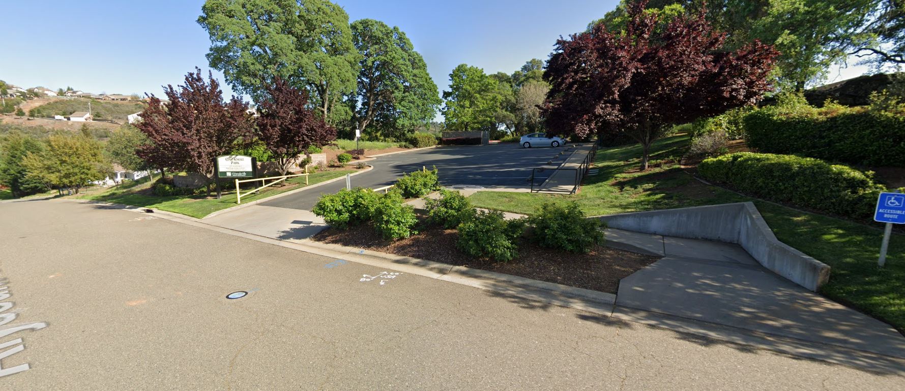
2021 Santa Run at Oak Knoll Park
Want to grab a photo with Santa and Mrs. Claus? Changes for 2022
We’ve heard from the EDH Fire Dept Elves that Santa has been eating healthy and has had a BIG growth spurt this year! Santa is coming in at about 6 feet 7 inches this year!!! – So when Santa and Mrs. Claus take pictures with the Kids this year, at the Oak Knoll Park Santa Stop, Santa and Mrs. Claus will be seated in front of the Oak Knoll Park parking lot driveway – this will help keep Santa and Mrs. Claus centered in photos with the Kids!!! Santa’s Elves have asked the everyone wanting to take photos with Santa and Mrs. Claus to line up in the Oak Knoll Park parking lot – don’t worry, everyone will get their pictures with Santa!
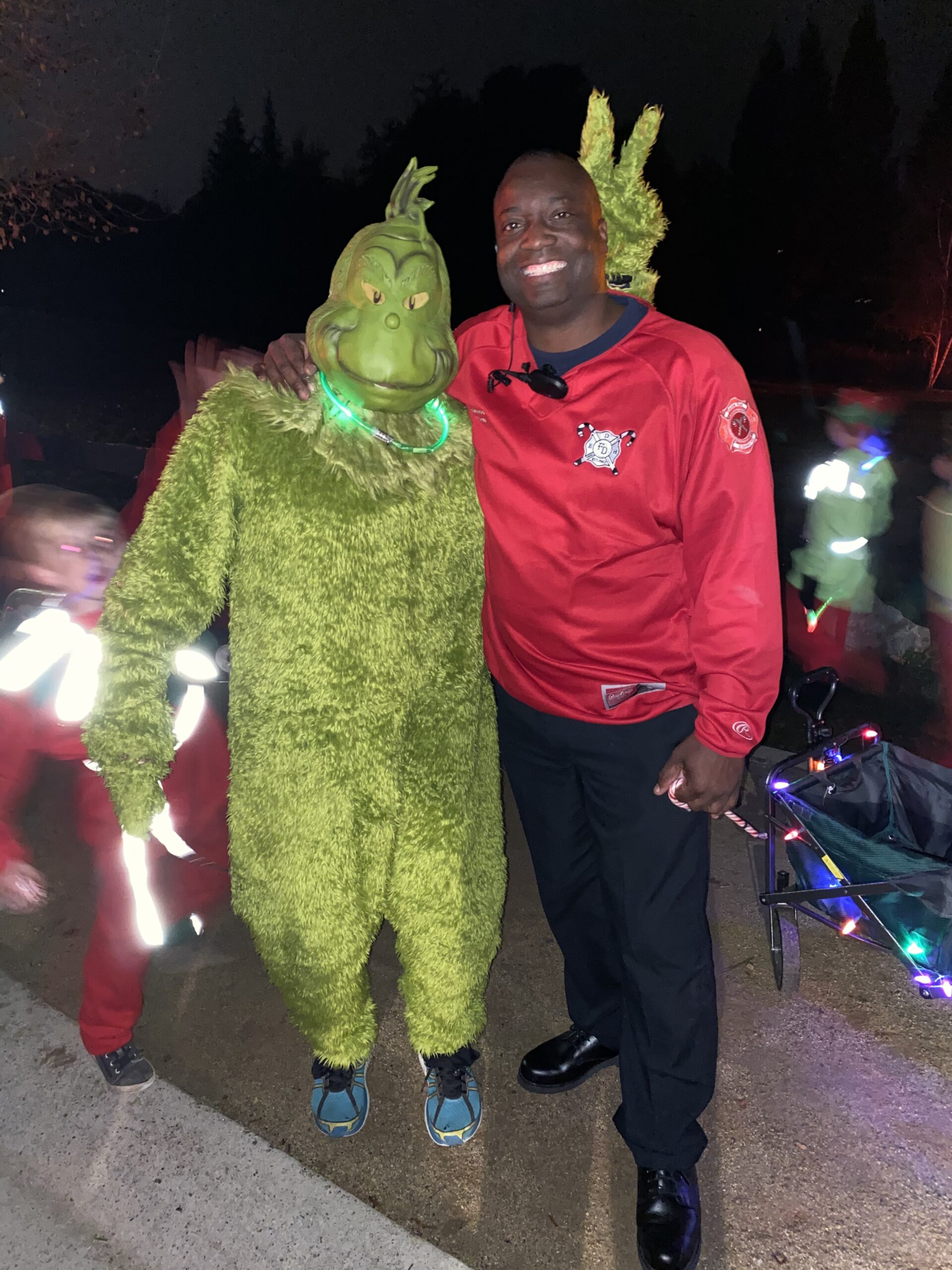
Santa’s Elves and maybe even The Grinch will be handing out Candy Canes as well!
We’ll have chairs ready for Santa and Mrs. Claus, plus a small table to drop off toy and food donations, as well as any Letters for Santa that need to be delivered.
Line up in the Parking Lot here for photos with Santa!!!
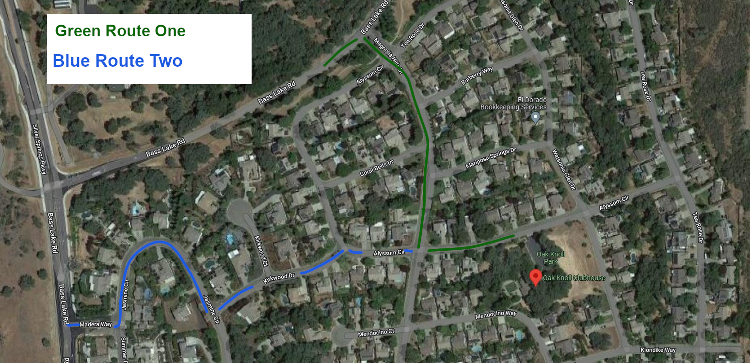
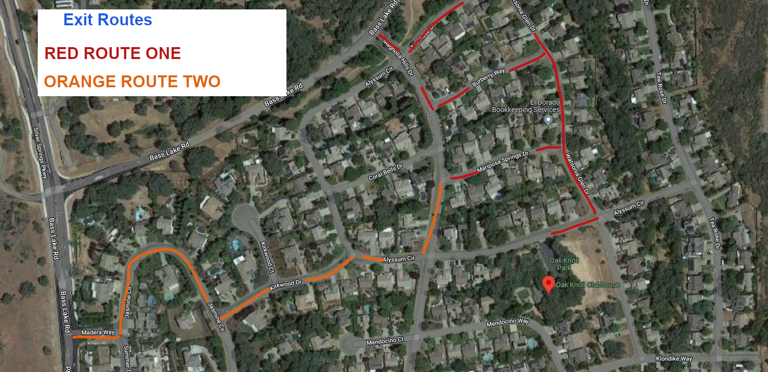
Santa’s Flight Path to Oak Knoll Park
Santa’s expected flight path to Oak Koll Park is expected to bring the Fire Engines and trucks from Bass Lake Road, onto Magnolia Hills Drive, then onto Alyssum Circle to Oak Knoll Park. When Santa leaves, the flight path is expected to head down Watsonia Glen Drive to Tea Rose Drive, and then back to Bass Lake Road to head to Bridlewood Canyon, and later to Laurel Oaks Park. We were out with Santa’s Elves pre-flighting the route on Friday, and we discovered that the powerlines on Bass Lake Road at Magnolia Hills Drive are very low, and Santa’s sleigh is sitting a bit higher on the EDH Fire Engine this year – also, the oak trees in the greenbelt along Tea Rose Drive are very, very low this year – so Santa’s flight path might instead be changed by air traffic controllers after they check the route one more time and bring Santa in from Bass Lake Road on Madera Way, Jasmine Circle, and then up Kirkwood Drive to Alyssum Circle, and when he leaves he may cut over from Watsonia Glen Drive on Burberry Way, or Mariposa Springs – so make sure that roads stay clear for Santa’s take-off!
Flight path into Oak Knoll Park: Green Primary Route – Blue Alternate Route
Departure Flight paths from Oak Knoll Park
Remember – let’s try to keep out of our neighbors’ yards, while also keeping the street clear for Santa and the EDH Fire Department.
The Grinch along with El Dorado Hills Fire Department Chief Maurice Johnson
Let’s show Santa that we’re ready to help the Holiday Heroes Food and Toy Drive on Thursday night!!!
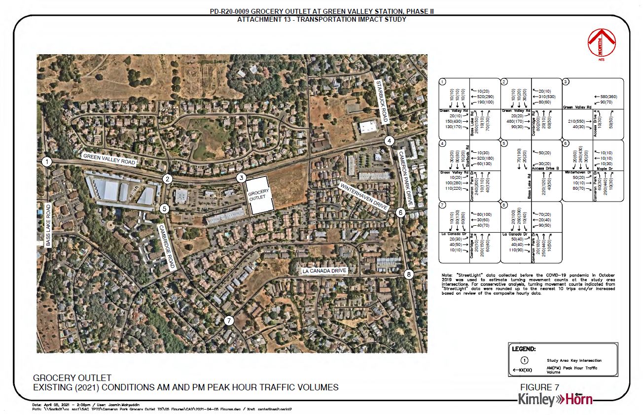
Analysis suggests that anticipated traffic volume increases have not materialized after 15 years.
A El Dorado County Land Use and Dev Services Public Notice has notified El Dorado County residents of a planned hearing before the County Planning Commission on April 14, 2022.
The County of El Dorado Planning Commission will hold a public hearing in the Planning Commission Hearing Room, 2850 Fairlane Court, Placerville, CA 95667 on April 14, 2022, at 8:30 a.m., to consider the following: Tentative Subdivision Map Revision TM-R21-0001/Summer Brook submitted by BLUE MOUNTAIN COMMUNITIES, INC., request for a revision to the approved Summer Brook Tentative Map and Planned Development TM07-1440/PD07-0007 to remove Conditions of Approval No. 25, 27 and 28 requiring installation of a traffic signal and completion of, or financing for, associated intersection improvements prior to final map recordation. In lieu of a financial contribution, the applicant may instead propose the submittal of construction documents for the signal and which support construction by others once a signal warrant analysis justifies installation
Condition of approval #25 from the March 11, 2008 project approval by the County Board of Supervisors:
25. The applicant shall signalize the Green Valley/ Deer Valley Road intersection to meet current El Dorado County Standards, as required in the approved traffic study. These Required improvements shall include the geometric improvements to Green Valley Road consistent with the approved improvements plans for CIP Project No. 66114 which includes the intersection widening to provide for right and left tum channelization and acceleration/deceleration lanes and shall adhere to the latest version of the Manual Uniform Traffic Control Devices (MUTCD), the California Supplement, and the Caltrans Highway Design Manual. The improvements shall be substantially completed to the approval of the Department of Transportation or the applicant shall obtain an approved improvement agreement with security, prior to the filing the final map.
From the Applicant’s Application Packet to revise the project tentative map conditions of approval:
During the review of the Dixon Ranch project traffic analysis, County Staff discovered a change in the traffic warrant situation in the area. On August 16, 2018 Staff directed the applicant’s consulting engineer to reevaluate the traffic signal warrants associated the intersection of Green Valley and Deer Valley Roads. The applicant’s consulting engineer (Kimley Horn) completed a traffic signal warrant evaluation on March 28, 2019, updated June 4, 2021. Results of these analysis confirm that installation of a traffic signal at this location is not warranted at this time. Further, street improvements were recently completed at the subject intersection. This significantly improved the situation since the 2007 report. Please see attached traffic signal evaluation reports completed by Kimley Horn. Because the traffic warrant for the signalization of the intersection is not satisfied, Staff directed the consulting engineer determined this project’s fair share contribution as part of the analysis. The applicant’s fair share has been calculated at 3.9%.
Section 66498.2 of the California Subdivision Map Act allows for the amendment of a tentative map in the event of a change to an ordinance, policy, or standard. The required street widening improvements have been completed. The completion of these street improvements effectively satisfies the street improvement portion of the requirement. In deciding if a traffic signal will be an asset rather than a potential liability, traffic engineers evaluate accepted warrants for traffic signals, in this case using the California Traffic Manual Uniform Traffic Control Devices. The installation of a traffic signal should be considered if one or more of the warrants in the referenced manual is met. The decision to install a traffic signal should not be based solely upon the warrants, since the installation of a traffic signal may increase certain types of collisions, and increase delays to pedestrians, bicyclists and drivers who use the intersection. The California Manual on Uniform Control Devices criteria per the requirement were applied in the Kimley Horn analysis and warrants for the following were not met: • Warrant 1: Eight-Hour Vehicular Volume • Warrant 2: Four-Hour Vehicular Volume • Warrant 3: Peak Hour • Warrant 4: Pedestrian Volumes
The projected traffic volumes that would have warranted a traffic signal have not materialized. Although the standard has not changed, the standard has not been met as projected. In fact, the installation of a signal at this location could create an unsafe situation. At Staffs request an updated traffic warrant study was undertaken which resulted in warrants not being met. Because warrants have not been met, the applicant requests the tentative map be amended modifying Condition No. 25 to eliminate the installation of a signal by the applicant and require the applicant pay the project’s fair share cost of the signal.
Fair Share: The Kimley Horn traffic signal warrant evaluation determined that the project’s fair share contribution to the signal is 3.90% or an estimated $10,000-$12,000. The applicant has contracted with Kimley Horn to design traffic signal construction plans for the intersection of Deer Valley /Green Valley. The plans will allow the traffic signal to be built at the time warrants are met. The applicant proposes that these plans be used to satisfy the project’s fair share of the signal costs. In fact, the actual contracted cost for the signal design ($17,000) exceeds the applicant’s fair share cost for the traffic signal.
Request: Blue Mountain Communities requests modification to TM07-1440-R-2 Department of Transportation condition 25. Specifically, we request that Condition No. 25 be modified such that the applicant/owner be required to contribute its fair share to the subject traffic improvements as detailed in the traffic signal warrant evaluations prepared by Kimley Horn and attached hereto. Further, its is requested that the traffic signal design plans being prepared by Kimley Horn for Blue Mountain Communities serve as Blue Mountain’s fair share contribution.
Improvements to the Green Valley Road – Deer Valley Road intersection were completed in 2014 along with the addition of the Green Valley Road – Silver Springs Parkway Intersection/signalization project, conditioned by the approval of the Silver Springs residential development , which satisfied elements of CIP Project No. 66114 which included the intersection widening to provide for right and left tum channelization and acceleration/deceleration lanes.
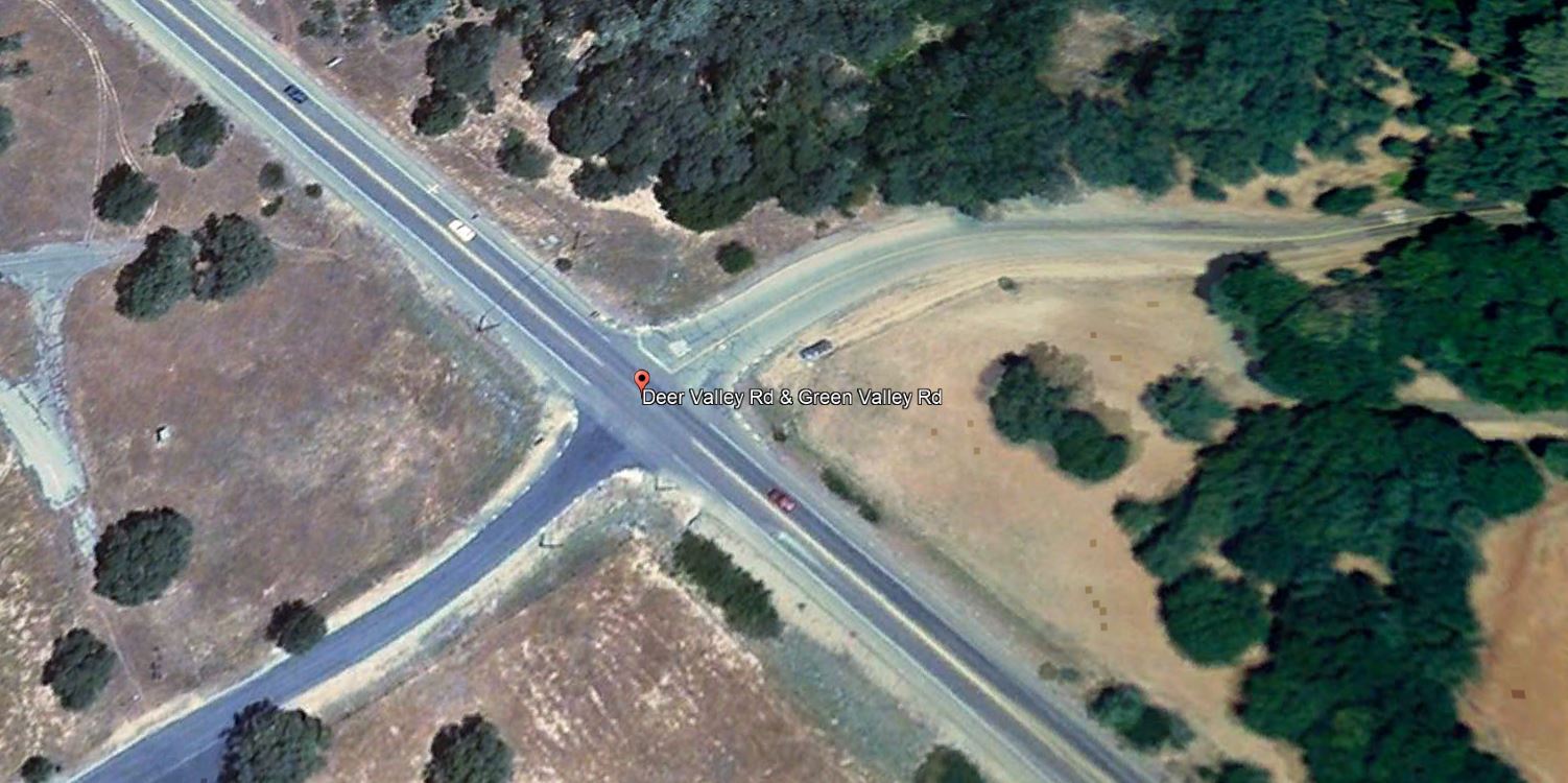
Green Valley Road at Deer Valley Road (west) satellite image from 2008 when the Summer Brook Project was approved by the Board of Supervisors
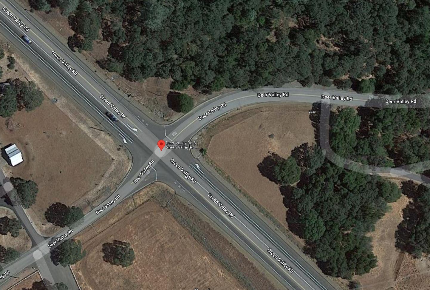
Green Valley Road at Deer Valley Road (west) satellite image from 2021, following widening, and turn pocket improvements from 2014
Blue Mountain Communities purchased the Summer Brook property in 2021, and are currently developing the approved 29 residential lots. They also purchased the Silver Springs property across Green Valley Road in 2018, and are currently developing 37 homes in phase 1 of the Revere at Silver Springs project.
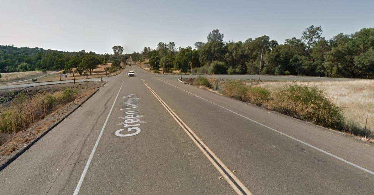
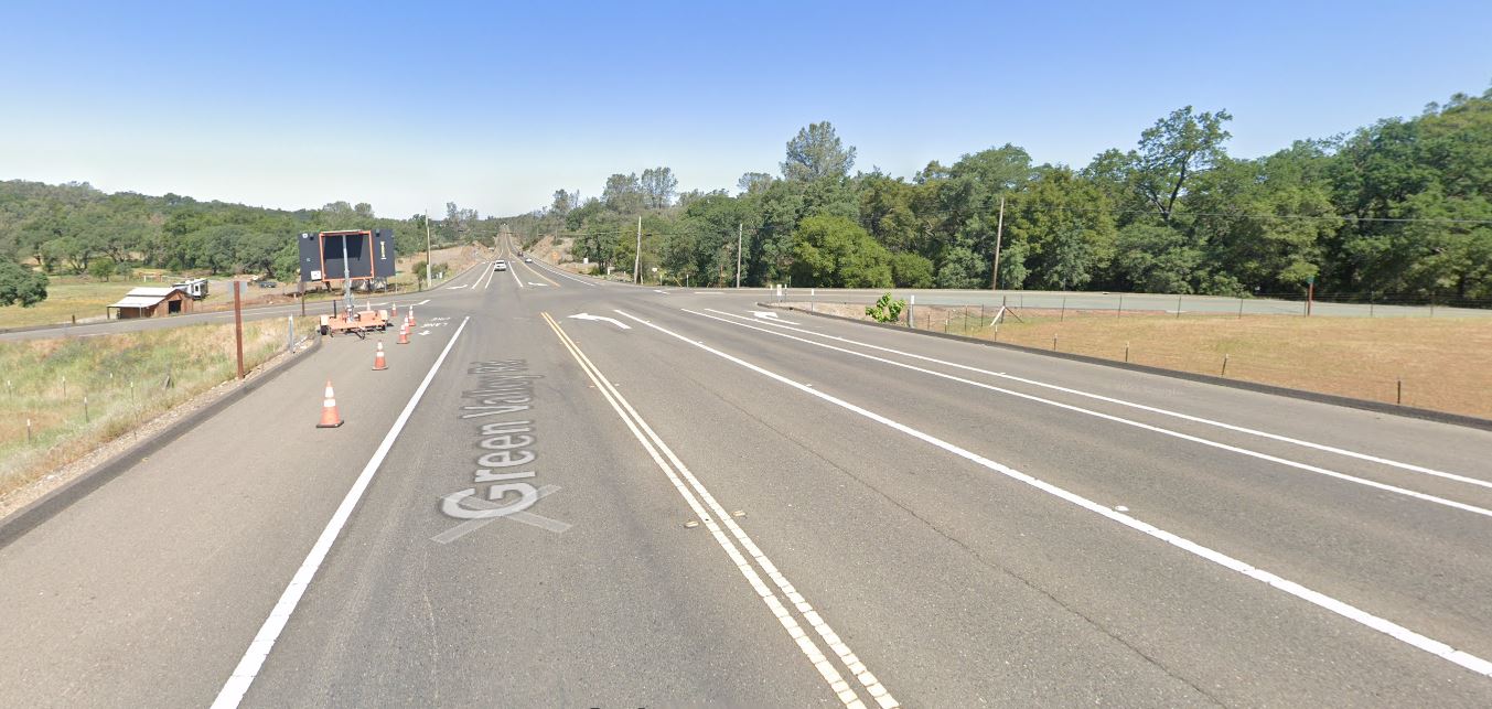
Green Valley Road looking west towards the Deer Valley Road (west) intersection in 2012, prior to road improvements in 2014
Green Valley Road looking west towards the Deer Valley Road (west) intersection in 2021, following road improvements in 2014
Over-optimistic growth/planning projections, and road improvements lost
Bass Lake Area residents in Rescue, Cameron Park, and El Dorado Hills, will notice a pattern – planned and promised road and pedestrian circulation and safety improvements, conditioned by multiple development applications from over 30 to 20 years ago, being delayed or removed from the County’s list of projects, primarily based on inaccurate analysis and projections from the late 1980s, the 1990s, and the 2000 – 2015 era. Frustratingly for area residents is that the analysis of multiple development projects resulted in findings regarding impacts on our communities from twenty, and even thirty-plus years ago had provided the blueprint for the growth of the Bass Lake Area, but the analysis, findings, and mitigations continue to unravel. Multiple projects over those many years were approved with the assumptions of cumulative impacts between them all, and intertwined conditions of approval. Recent analysis of these projects as they are revisited have led to many improvement projects disappearing from the planning horizon:
The removal of CIP projects for constructing a four lane Bass Lake Road in 2015, and 2016
The removal of frontage improvements (Sidewalks, turn pockets, and bicycle lanes) for Bass Lake Road provided by specific projects in the 1988 El Dorado Hills Specific Plan, as those projects were updated in 2017 and 2019
Removal of planned elements of Bass Lake Road improvements included in the 1996 Bass Lake Hills Specific Plan, in 2016-17.
Removal of four lane Bass Lake Road improvements from US50 to Serrano Parkway attributed to a finding that Bass Lake Road from the re-aligned Country Club Drive north to Serrano Parkway exists in the El Dorado Hills Community Region, and Bass Lake Road from Country Club Drive south to US50 exists in the County Rural Region in 2019-20 – Level of Service (LOS) metrics/triggers differ between community and rural regions.
Public Comments regarding TM-R21-0001
If you would like to provide public comments to the Planning Commission prior to the April 14, 2022 hearing, you can submit fact based informed comments to planning@edcgov.us . Remember, emotion is not part of the deliberative process of the Planning Commission, so respectful comments, related to your concerns or questions, make for the most productive discussion.
The County has four new draft maps prepared for what should be the final redistricting hearing to determine Supervisor districts for the next ten years. The hearing is scheduled for 1:30PM on Tuesday November 16th.
The good news – the Supervisors have heard the voices of the Bass Lake Area
Only thirty written comments were submitted to the Supervisors prior to their last redistricting meeting on November 3rd, and over TWENTY of those thirty written comments were from Bass Lake Residents. The Supervisors heard your concerns and almost all of them agreed that the Bass Lake Villages of Bridlewood Canyon, Woodridge, and The Hills of El Dorado are a community of interest, and should be represented in the same supervisor district.
At the November 3rd hearing, the Supervisors determined that the City Draft Alternative 2 Map and the El Dorado Hills Community Draft Alternative were map options that they wanted to explore, and asked that County staff incorporate our community concerns to come back with the final set of draft alternatives.
Of the four final maps
City Revised 2A – separates our Bass Lake Villages and the Serrano communities on the east and south sides of Bass Lake from the Bass Lake communities on the west side of Bass Lake, putting the east and south sides of Bass Lake into District 2, and keeping the west side in District 1. This is less than optimal for all of our Bass Lake communities, on both sides of Bass Lake.
City Revised 2B – Keeps our Bass Lake Villages in District 1, but separates the El Dorado Hills Communities south of US50 that have asked to remain in a single district (Four Seasons, Heritage, and Blackstone) into District 1 and District 2. Our El Dorado Hills neighbors south of US50 have supported the Bass Lake Area in our desire to remain in a single suburban district, and we would like to support their desire as a community of interest to remain in a single district. El Dorado Hills Community Revised A – This alternative keeps our Bass Lake Villages in District one, and supports our El Dorado Hills neighbors south of US50. However, it adds a massive area of rural land north of El Dorado Hills to District 1, and more significantly, moves the District 2 boundary so far east, that it takes the District 4 supervisor, and places her residence into District 2. She’s already announced her re-election campaign for 2022. Political alignments and considerations CANNOT be used as part of the redistricting process – but to be honest, Supervisors are the decision makers in this process in El Dorado County, and in all reality, that would be an automatic no-vote from one supervisor out of five supervisors, and we need three yes votes to support our choice.
El Dorado Hills Community Revised B –This alternative is the one that we believe we should support. It keeps the Bass Lake Villages on the east side of Bass Lake in one district with our neighbors on the west side of Bass Lake, and it keeps us aligned with the majority of El Dorado Hills. It also respects the desire of our El Dorado Hills neighbors south of US50 to remain in a single district. Another benefit is that it keeps our neighbors in Cameron Park in one District – they have been separated and underrepresented in two districts prior to this. This combines 19,000-plus Cameron Park residents and 9,000 El Dorado Hills residents south of US50 to become a block of over 28,000 suburban residents out of 38,000 residents in District 2.
Closeup view of the El Dorado Hills Community Revised B Map
If you feel that you could support the El Dorado Hills Community Revised B draft alternative, could you submit written comments to the Board of Supervisors before the Monday November 15 4PM deadline?
Here is a sample letter of support you could use. Your previous written comments had a positive impact on letting the Board of Supervisors know that the Bass Lake Area is a significant Community of Interest, and moved the needle for our community in the redistricting process.
Subject: November 16, 2021 Agenda Item 40 – Public Workshop on the 2021 Redistricting Process (Redistricting Public Hearing #5)
Honorable Supervisors,
As residents of the Bass Lake Area in El Dorado Hills, we deeply appreciate your concern and instructions to County staff to keep our Bass Lake Community of Interest intact in a single supervisorial district.
In reviewing the draft alternative maps as proposed, we believe that the best option for representing the interests of our Bass Lake Community, El Dorado Hills, our El Dorado Hills Neighbors’ Community of Interest south of US50, and our suburban neighbors in Cameron Park, is to support the El Dorado Hills Community Revised B Map.
This map keeps our communities aligned, supports suburban communities of interest where no local city representation exists, keeps the Bass Lake Community intact, keeps Cameron Park in a single district, keeps our Serrano neighbors’ community of interest intact, and keeps most specific plans intact in District 1 and District 2.
Out of the four Draft Alternative Maps, we urge you to support El Dorado Hills Community Revised B Alternative Map. It represents the best available compromise that respects communities of interest in the largest population centers of El Dorado Hills and Cameron Park in El Dorado County. The El Dorado Hills Community Revised B Alternative Draft Map meets each of the mapping factor priorities, and aligns with the desires of our various Communities of Interest:
Geographic contiguity.
Geographic integrity of neighborhoods and local communities of interest.
Geographic integrity of cities or census-designated places.
Natural and artificial barriers, including streets and boundaries of the county when practicable.
Boundaries should be easily identifiable and understandable by residents, and bounded by natural and artificial barriers.
Geographical compactness.
Thank you for supporting our communities.
Please make sure that you remain respectful in your comments, as supervisors instantly turn off pleas based on emotion.
Remember: Your comments should be submitted BEFORE 4:00PM on Monday November 15!!! Thank you for your consideration to provide your comments to the Board of Supervisors.
This is an URGENT appeal to Bass Lake Area Residents to provide written comments to the Board of Supervisors by tomorrow, Tuesday November 2 before 4PM.
This is your opportunity to share with the County Supervisors how you believe district boundaries should be drawn to best represent our Bass Lake community.
The final DRAFT alternative redistricting maps are being presented to the Board of Supervisors at a special meeting on Wednesday November 3rd at 9AM. In EACH of the three proposed Draft Alternative Maps the Bass Lake Villages are being split between two districts – the District 1 eastern boundary line is proposed to be the FENCE LINE between Bridlewood Canyon, and Woodridge – meaning that Bridlewood Canyon will remain in District 1, while Woodridge and The Hills of El Dorado will be moved to either District 4 or District 2.
Here is City Alternative 1
Here is City Alternative 2
Here is the Pollock Pines Draft Alternative:
Seeing the exact boundary in these drafts is very difficult – but basically, the boundary is the fence/wall between backyards in Bridlewood Canyon and Woodridge:
These maps were drawn this way because the Serrano Homeowners Association wanted all of their members in a single district – which we support, because they are a Community of interest. But the changes to the Draft Alternatives to accommodate Serrano Homeowners Association’s request also moved Bridlewood Canyon into District 1 with the Serrano Village J7 (where NO RESIDENTS LIVE YET) because they share a property wall. However, no consideration has been given to the separation of Woodridge and The Hills of El Dorado from Bridlewood Canyon, even though as neighbors we have shared a fence line / wall for twenty years. The Bass Lake Villages are as much a Community of Interest as any other community in the County – we have the same concerns and issues as neighbors on the eastern side of Bass Lake. We are neighbors – dividing our neighborhoods divides our voice in Supervisor representation.
There is currently a conceptual Daft Alternative map from a working group of El Dorado Hills residents, which includes members of the Bass Lake Community, Highland Hills Community, the Serrano Homeowners Association, Heritage Homeowners, the Age Restricted Communities along White Rock Road and Latrobe Road, and the El Dorado Hills Chamber of Commerce – we requested a more natural split of El Dorado Hills north and south using US50 as a natural boundary line, as it does not separate neighborhoods, and provides large representation of El Dorado Hills in two districts (because El Dorado Hills is too large by population to fit in a single district) as the current crop of drafts proposes moving small numbers of El Dorado Hills residents into multiple districts, making our voices weaker.
Since the County seems intent on continuing to divide Cameron Park into multiple districts, our working group’s proposal is to place a significant part of Cameron Park into District 1 along with the areas of El Dorado Hills north of US50, and to move everything in El Dorado Hills south of US50 into District 2.
This will give El Dorado Hills more than 73% representation in District 1, with more than 25% of Cameron Park, and then also provide over 27% of El Dorado Hills residents to be in District 2 – keeping El Dorado HIlls with a significant population voice in two suburban-oriented districts. This also results in Cameron Park being over 30% of District 4, giving Cameron Park residents a large voice in two districts.
No official Draft Map for this community alternative is prepared from County Staffers yet.
We have been told that this El Dorado Hills Community Draft Alternative Map could be presented as the fourth draft option to the Board of Supervisors for their Wednesday November 3rd meeting, but there are no guarantees.
If you feel that you would support a draft alternative that keeps our Bass Lake Villages together, could you provide your comments to the Board of Supervisors in an email?
Our primary concern is keeping our Bass Lake neighborhoods in a single district, instead of allowing the County to split us apart based on a fence line.
If you choose to provide comment, here is a form letter that you can use:
Subject: October 3, 2021 Agenda Item 1 – Public Workshop on the 2021 Redistricting Process (Redistricting Public Hearing #4)
Honorable Supervisors, As residents of the Bass Lake Area, we ask that you consider keeping our Bass Lake Area neighborhoods whole, and not allow them to be split across multiple districts, as Draft City Alternative Revised 1, Draft City Alternative Revised 2, and the Draft Pollock Pines Alternative proposes to do.
The Bass Lake Villages on the eastern side of Bass Lake – Bridlewood Canyon, Woodridge, and The Hills of El Dorado – have existed as a Community of Interest for twenty years. We are neighbors, with similar concerns, interests, and needs. Dividing our community based on a fence line, as each of the three proposed draft alternatives seeks to accomplish, will diminish our voice as neighbors. A fence line is an artificial, arbitrary boundary for supervisorial districts.
We are a community of interest in respects to:
Our Town – the Bass Lake Villages were included in the borders of 2005 EDH Cityhood Ballot Measure
Our proximity as neighbors with similar concerns to our immediate local interconnected roads, public safety, and our natural environment
Our properties all exist in the El Dorado Hills CSD boundaries
Our properties all exist in the El Dorado Hills Fire Department boundaries
Our children all attend the same public elementary and high schools (Rescue USD and El Dorado High School District)
From your own meeting slides materials, the mapping factors in order of priority are:
Geographic contiguity.
Geographic integrity of neighborhoods and local communities of interest.
Geographic integrity of cities or census-designated places.
Natural and artificial barriers, including streets and boundaries of the county when practicable.
Boundaries should be easily identifiable and understandable by residents, and bounded by natural and artificial barriers.
Geographical compactness.
Keeping our Bass Lake Villages in a single district accomplishes each and every one of these goals. To do otherwise violates each and every element of the listed priorities.
The Bass Lake Villages are as much a Community of Interest as any other community in the County – as neighbors we have the same concerns and issues as residents of the eastern side of Bass Lake. We are neighbors – dividing our neighborhoods divides our voice in Supervisor representation.
In the event that the El Dorado Hills Community Draft Alternative map from a working group of El Dorado Hills neighbors is provided as an option prior to your meeting, we would encourage you to utilize this Draft Alternative, as we believe that it is the option to best represent the Bass Lake Area, as well as the best representation for El Dorado Hills and Cameron Park.
Our priority is to keep our Bass Lake Neighborhoods together in a single district.
Please make sure that you remain respectful in your comments, as supervisors instantly turn off pleas based on emotion.
Remember: Your comments should be submitted BEFORE 4:00PM on Tuesday November 2!!! Thank you for your consideration to provide your comments to the Board of Supervisors.
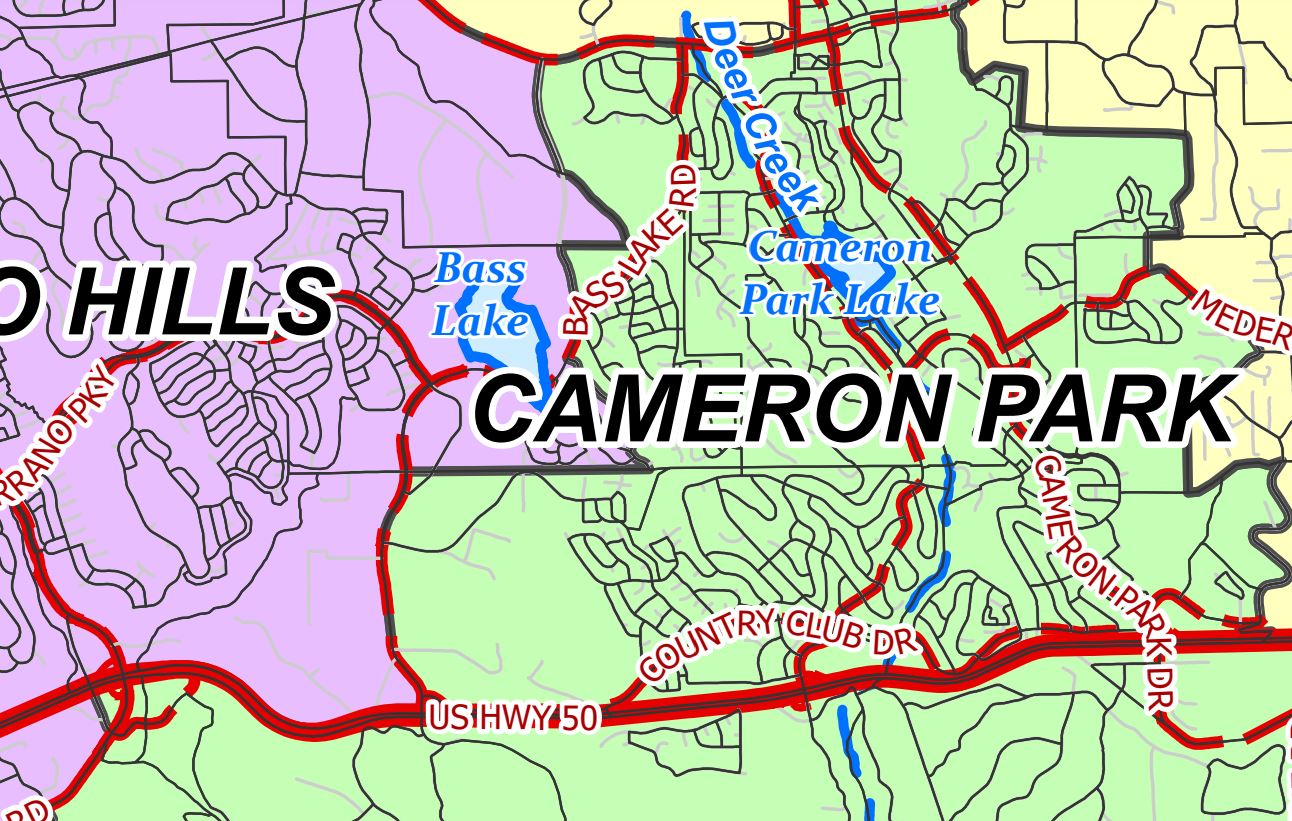
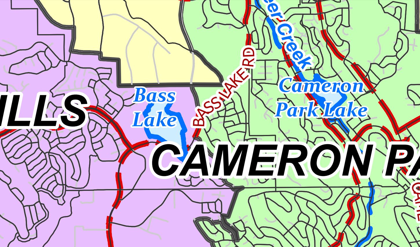
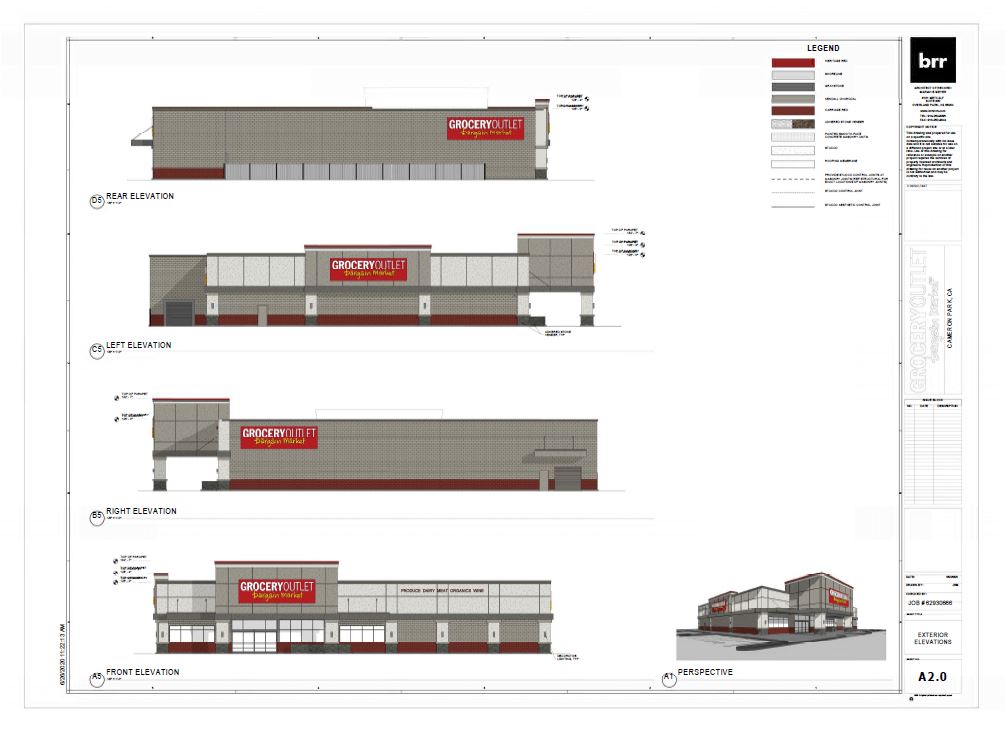
Proposed Grocery Outlet Store on Green Valley Road between Cambridge Rd and Winterhaven Dr
From the Mitigated Negative Declaration Project Description:
A Planned Development Revision, PD-R20-0009, to modify an approved development plan, PD05-0004 Green Valley Station, to allow development of a new 16,061 square foot market, Grocery Outlet, on a 2.0-acre portion of the 5.37-acre parcel. In accordance with the Parking and Loading Standards in the Community Design Standards, the project includes associated improvements for 77 standard parking spaces, four (4) handicapped-accessible parking spaces, lighting, landscaping, recycling/trash enclosures, building signage, and one freestanding monument sign. Access would be from Green Valley Road, a County-maintained roadway. The project includes road improvements to Green Valley Road, with a 6-ft wide meandering sidewalk along part of the northern property boundary line adjacent to Green Valley Road, and expansion of the existing utilities on-site by extending the public utility lines with 400-ft of sewer force main and 1,400-ft of waterline. Electricity/utilities would be provided by connecting to PG&E. Typical hours of operation are 8:00am-9:00pm 7 days per week, and the number of employees would be 30. There would be mutual access and reciprocal shared parking between both developments for Phase I and a portion of Phase II for the Green Valley Station.
PUBLIC REVIEW PERIOD: The public review period for the Draft MND set forth in CEQA for this project is 20 days, beginning August 27, 2021, and ending September 15, 2021. Any written comments must be received within the public review period. Copies of the Draft MND for this project may be reviewed and/or obtained in the County of El Dorado Planning and Building Department, 2850 Fairlane Court, Placerville, CA 95667, during normal business hours or online at https://edc-trk.aspgov.com/etrakit/ by typing the first word of the project name in the search box. (To view project documents, you MUST create a FREE eTRAKiT user account)
Please direct your comments to: County of El Dorado, Planning and Building Department, County Planner: Bianca Dinkler, 2850 Fairlane Court, Placerville, CA 95667 or EMAIL: planning@edcgov.us
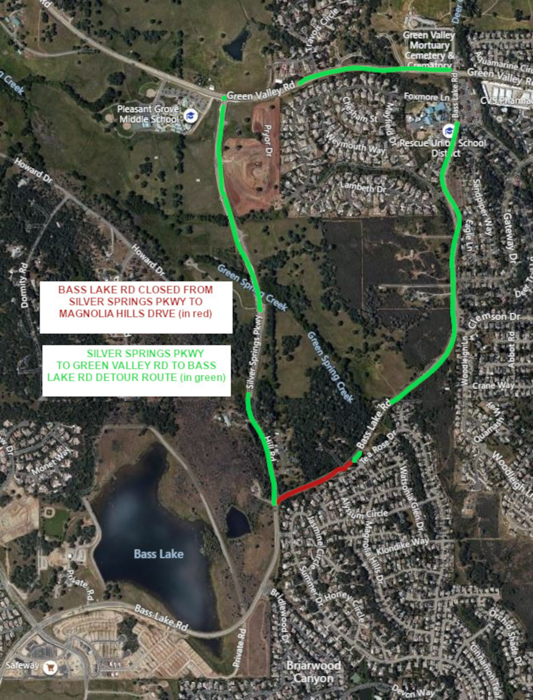
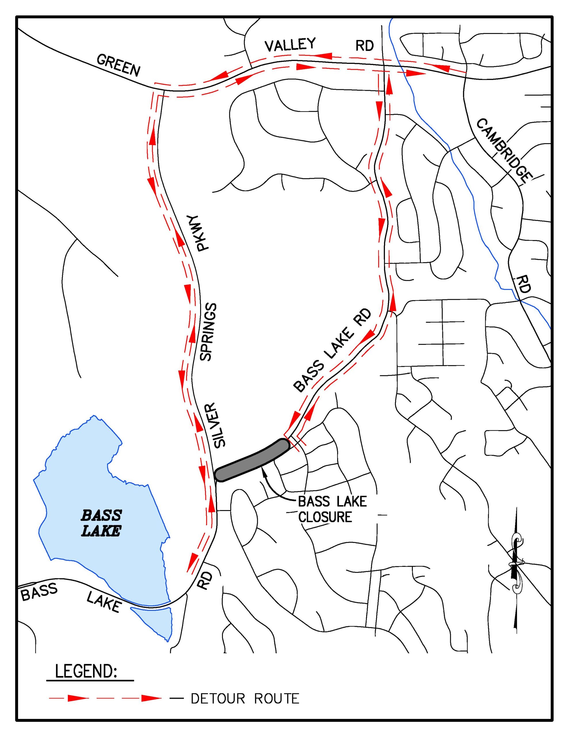
Detour available via Silver Springs Parkway & Green Valley Road
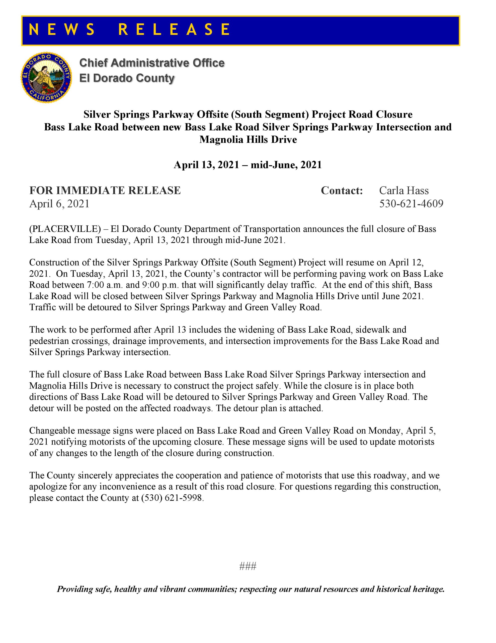
El Dorado County has announced the planned closure of Bass Lake Road at the new Silver Springs Parkway intersection just north of Madera Way in El Dorado Hills, beginning April 13, 2021, and will last through mid June 2021.
The closure will be in place between the new Silver Springs Parkway connection at the 25 MPH curve on Bass Lake Rd (Sandhurst Hill Rd) east to Magnolia Hills Drive.
On April 13th, crews from Granite Construction will spend the day paving the the new Silver Springs Parkway connection to Bass Lake Road – when the paving activity is completed on April13th, Silver Springs Parkway will be opened to motorists between Madera Way and Green Valley Road. This is the planned Detour route while Bass Lake Road is closed.
Per El Dorado County Department of Transportation, residents and motorists should expect significant and long delays on Bass Lake Road on April 13th, while the paving work is completed.
Planned Detour Route in Green – Bass Lake Road closure in Red
While Bass Lake Road is closed from Silver Springs Parkway to Magnolia Hills Drive, construction crews will realign Bass Lake Road and construct an ADA compliant sidewalk and crosswalks on Bass Lake Road at the new intersection. Southbound Bass Lake Road will be constructed with left and right turn lanes – the left lane will be for motorists traveling south on Bass Lake Road towards US50, the right turn lane will allow motorists to continue north onto Silver Springs Parkway, towards Green Valley Road. Northbound Bass Lake Road at the new Silver Springs intersection will feature a straight through lane to continue north on Silver Springs Parkway towards Green Valley Road, as well as a right turn pocket for motorists to continue north on Bass Lake Road towards Magnolia Hills Drive, Woodleigh Lane, Gateway Drive, Lambeth Drive, Parkdale Lane, Foxmore Lane, and Green Valley Road.
Silver Springs Parkway will be a divided two lane roadway, with sidewalks and bicycle lanes.
The new Bass Lake Road-Silver Springs Parkway intersection will be a three-way stop sign controlled intersection.
Changeable Portable Reader Board signage will be in place to advise motorists of changing conditions and delays. Currently the changeable portable reader boards indicate that the closure is expected to be in place from April 13th through June 11th – the completion date is subject to change due to weather delays, and possible utility relocation delays from PG&E and AT&T.
Bass Lake North 90 home subdivision appeal hearing at the Board of Supervisors Dec 8th
The Bass Lake North project was approved in 2017 by the Board of Supervisors – it is located in the Bass Lake Hills Specific Plan area, along Sienna Ridge Road just south and east of the Sienna Ridge Shopping Center.
One of the conditions of approval in 2017, Condition of Approval 66 (COA 66) was that the project would build 100 vehicle spaces of the eventual 200 space Park and Ride facility that will be located on the south west side of the new Bass Lake Road – Country Club Drive signalized intersection. Ten of the proposed spaces are also considered for use in the eventual Mormon Carson Trail system in the Plan Area.
The Developer filed a request to reduce his obligation of 100 spaces to 50 spaces, and move the responsibility for the remaining 50 spaces to an undefined “future” development in the BLHSP Plan Area – meaning the next project would have to build the other 50 spaces. His request was based on the significant costs to build the Park and Ride spaces, and his determination that his 90 home project was being unfairly burdened with an excessive share of the Park and Ride Lot costs. During the public hearing, the developer also provided his own nexus analysis of the need for park and ride spaces in the area based on his status as a licensed civil engineer in California – his determination was that the full build out of the entire Bass Lake Hills Specific Plan area would only generate the need for a little more than 11 total park and ride spaces, and that his project specifically would only generate the need for less than four spaces.
The request also sought to have the option of paying El Dorado Transit Authority for “in lieu fees” instead of even building just the 50 parking spaces.
After three hours of testimony at the Nov 12th Planning Commission Hearing, the Planning Commission voted 3-2 to deny the change request. The Developer has filed an appeal of the Planning Commission denial with the El Dorado County Board of Supervisors, with the hearing scheduled for December 8th.
The Bass Lake North Project is also required via Condition of Approval 67 (COA 67) to build a segment of Class 1 bicycle lane from the old Country Club Drive intersection to the end of the existing bicycle lane along Bass Lake Road at Hollow Oak Road. This was a Board of Supervisors-added condition of approval at the project hearing in February 2017. The Developer agreed to the Park and Ride Construction, and the Class 1 Bicycle lane construction.
The Developer suggested during the Nov 12th Planning Commission Hearing that the Class 1 Bicycle lane was a last minute add-on, and considered that it was important to the District 2 Supervisor, and was more valuable to the community than the full 100 spaces of the Park and Ride Lot. Hinting that the end result could be a choice of providing a 50 space Park and Ride Lot and a Class 1 Bicycle Lane, or just the 100 spaces of the Park and Ride Lot, with no Class 1 Bicycle Lane.
It is important to remind the Board of Supervisors that they are not under any obligation to accommodate the Developer’s request: The entitlements for the approved project requires BOTH construction of 100 spaces of the Park and Ride Lot, and the Class 1 Bicycle Lane. There is no need to trade parts of one COA for another. The Park and Ride Lot Construction costs will be fully refundable to the applicant through the Public Facilities Financing Plan (PFFP) of the Bass Lake Hills Specific Plan.
At the Nov 12th Planning Commission Hearing, the El Dorado Hills APAC offered one of only two public comments on the project request (here), asking the Planning Commission to deny the change request.
More resident public comments could improve the chances that the Board of Supervisors will reject the appeal, and require the developer to construct both the 100 spaces of the Park and Ride Lot, as well as the Class 1 Bicycle Lane, as originally intended by the project conditions of approval. Even just emailing in a form letter may make the difference.
The history of Bass Lake Road development is replete with after-the-fact-changes to approved projects and planned improvements – which is why Bass Lake Road had three long scheduled Capital Improvement Plan (CIP) projects removed in 2016 from the CIP project list:
In fact, at the Nov 17, 2020 Board Of Supervisors hearing regarding the 2020 TIM fee program update, the Transportation Dept. Director told the County Supervisors that Bass Lake Road was unlikely to be getting these improvements back on the CIP list in the 20 year horizon, because conditions (traffic volume, and road conditions) were not projected to warrant the improvements.
Public comments can be emailed to the Clerk of the Board of Supervisors by Monday December 7th. Getting public comments in before the close of business will ensure that the comments are seen by the Supervisors prior to the hearing. Comments should be respectful, and fact based, and not depend on emotion, which tends to get ignored.
Would you consider submitting public comments on the Bass Lake North Appeal hearing?
Sample Form Letter – copy and paste into your own email message to the Board of Supervisors:
COPY and PASTE the sample letter below andemail to: edc.cob@edcgov.us
SUBJECT: Denial of Tentative Subdivision Map Revision TM-R19-0002 Bass Lake North
Dear Supervisors,
I ask that you uphold the Planning Commission’s November 12, 2020 denial of the Tentative Subdivision Map Revision TM-R19-0002 Bass Lake North request to revise the Condition of Approval #66 that sought to reduce the required constructed quantity of park-and-ride parking spaces from 100 to 50 and phasing the remaining 50 spaces as a Condition of Approval for future subdivision(s) within the Bass Lake Hills Specific Plan area.
The Planning Commission’s reasons for denial were:
No technical analysis or justification was presented to support the applicant’s request;
The El Dorado Transit Master Plan, testimony from the Transit Authority and Public Comment shows a need for the Park-and-Ride spaces and the Transit Authority Board has not vetted any technical analysis for this request;
These projects (Park-and-Ride spaces) are going to be fully refundable to the applicant through the Public Facilities Financing Plan (PFFP);
The intention of the Bass Lake Hills Specific Plan was to front load the needed infrastructure;
The assertion that it would be reasonable to push the requirement of the additional 50 Park-and-Ride spaces to potential future projects (potentially smaller future projects) would be unfair to those future projects and applicants;
The applicant agreed to the front loading infrastructure as approved and conditioned by the Planning Commission, and the Board of Supervisors additional condition of approval to include a bike path; and,
The current approved project is more consistent with the Bass Lake Hills Specific Plan and the County General Plan than the proposed modified request as presented to the Planning Commission.
Changes to anticipated traffic levels, build out projections, and deferring infrastructure improvements to undefined future development is how Bass Lake Road became a road with three Capital Improvement Plan projects removed in 2015/16.
The El Dorado Transit Authority had based their needs for Park and Ride lots on an analysis that predates the 2017 approval of the Bass Lake North project. El Dorado Transit Authority’s recent concession to the applicant’s request to change from 100 funded parking spaces to 50 parking spaces is not based on any meaningful analysis.
The Park and Ride is also intended to provide 10 joint use parking spaces anticipated to be used for the Mormon Carson Trail within the Bass Lake Hills Specific Plan Area.
Further, on page 107 the Bass Lake North Project CEQA Addendum and Initial Study of Environmental Significance, approved by the Board of Supervisors on February 28, 2017 specifies that development of a park and ride facility near the intersection of Bass Lake Road and Country Club Drive should be required in conjunction with the development of the area.
Also, that a portion of the Class 1 Bicycle lane from Old Country Club Drive to Hollow Oak Road had to be added to the Specific Plan and this project without analysis during the Board of Supervisors hearing in 2017, further demonstrates a lack of full consideration for the facilities and circulation elements in the 2016/17 updated Bass Lake Hills Specific Plan. The County should not be trading Conditions of Approval after the fact.
Both the Park and Ride Lot and the Bicycle lane are facilities that are lacking in the Bass Lake Area, and trading required Conditions of Approval years after the project has been approved, in deference to cost increases, does not serve the interests of residents or the County. Additionally, the park and ride facility construction costs are reimbursable to the developer.
I request that both Condition of Approval #66 (the 100 spaces in the Park and Ride Lot) and Condition of Approval #67 (the Class 1 Bicycle lanes) not be modified for this project, and that you uphold the Planning Commission Denial of the request, and refuse the appeal.
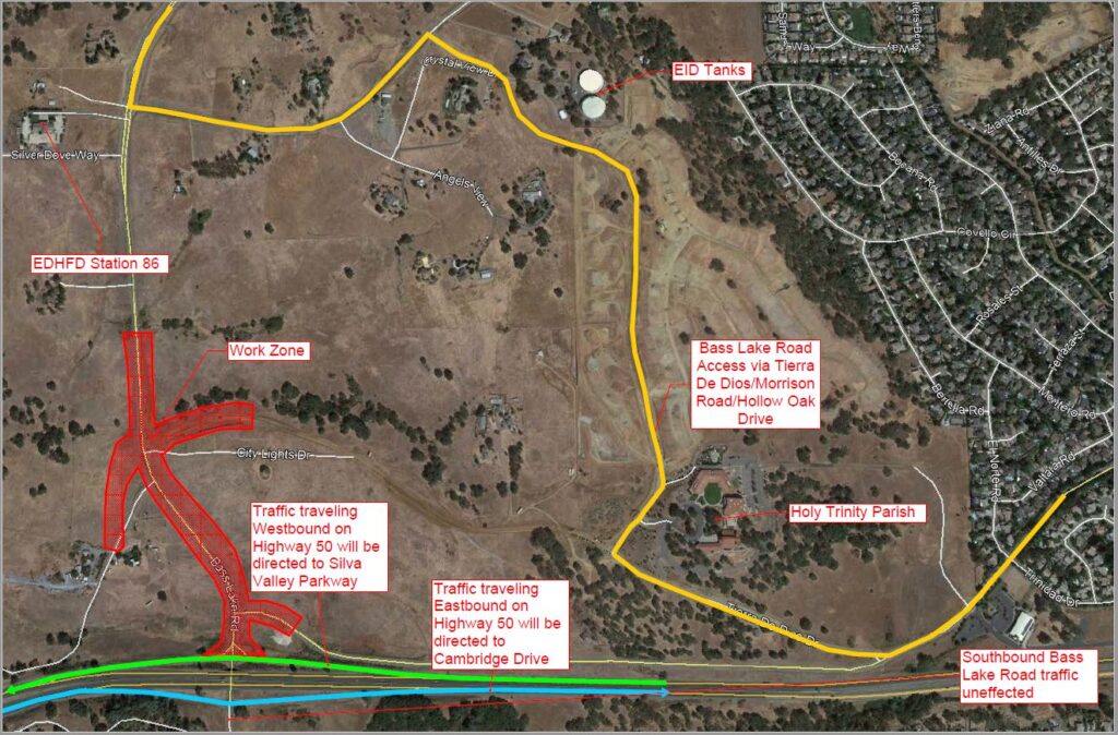
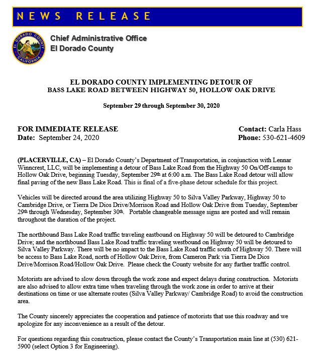
El Dorado County has issued a press release with details of the fifth, and final, detour of Bass Lake Road for the Country Club Drive-Bass Lake Road realignment and signalization project.
The final detour will begin the morning of Tuesday September 29th, at 6:00AM and is scheduled to continue through Wednesday September 30th.
This detour will allow for the final paving activities on the new segment of Bass Lake Road, and matching the pavement sections to the west bound Bass Lake Road on and off ramps at the US50 Interchange.
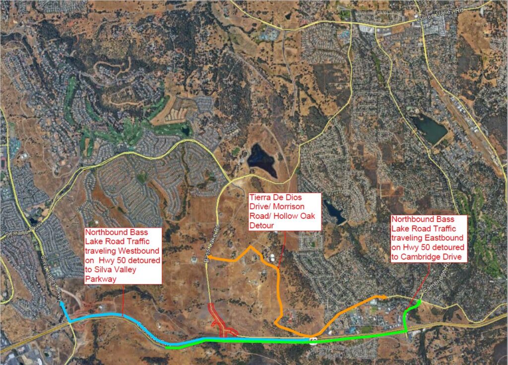
Close up view of planned Bass Lake Road PHASE 5 Detour routes – Tierra de Dios Drive to Morrison Road to Hollow Oak Drive. Construction areas in RED are closed, including the US50 west bound on and off ramps.
Bass Lake Road will be closed from US50 north to the new Country Club Drive intersection (shown red on the detour map above). Motorists traveling south on Bass Lake Road will NOT be able to access the US50 interchange. Instead motorists on Bass Lake Road should use Serrano Parkway to Silva Valley Parkway to US50, or use the planned detour route of Hollow Oak Drive to the NEW Morrison Road to Tierra De Dios to Country Club Drive to Cambridge Drive Shown in Yellow on the map above, and below.
Bass Lake Road PHASE 5 Detour Routes – East Bound US50 On and Off Ramps are open to Bass Lake Road and Marble Valley Road traffic SOUTH of US50.
Bass Lake Road will be open to the El Dorado Hills Fire Station 86, as well as to private driveways north of the construction site at the NEW Country Club Drive intersection.
The US50 on and off ramps at the Bass Lake Road Interchange will remain open for motorists traveling on the south side of US 50 along Marble Valley Road.
The Bass Lake Action Committee would remind drivers to exercise caution in the construction areas, as well as at the Bass Lake Road – Hollow Oak Drive intersection, which has very poor sight-lines.

 Loading...


