In October the Bass Lake Action Committee published a poll from our Traffic and Safety Committee, which focused on garnering community feedback about prioritizing potential safety improvements along Bass Lake Road for traffic, pedestrians, and bicyclists. To be clear, many obstacles would have to be overcome for any of these potential safety improvements to be approved and funded, but the goal of the poll was to determine what improvements that our Bass Lake Community wanted to prioritize.
Based on the poll results, safety improvements were the top priorities identified by the Bass Lake Community. Community members also identified needed capacity improvements, but focused on traffic and pedestrian safety items.
The number one priority identified by residents was the need for a Multiuse Pedestrian & Bike Path from Silver Springs Pkwy to Sienna Ridge Rd. Since the Sienna Ridge Road shopping center was completed, there has been no pedestrian pathway or bicycle lane to connect the 1000-plus homes on the east side of Bass Lake. Consequently, pedestrians are left to walk along the edge of Bass Lake Road utilizing the narrow dirt foot path on the outside of the guardrail where the road crosses the Bass Lake overflow. Bicyclists have to try to navigate the edge of Bass Lake Road.
The second highest priority in the poll results was for turn pockets at the entrances of residential villages. The entrances for the Serrano J6 and J7 Villages along Bass Lake Road at Whistling Way and Barbary Way were not required to construct frontage improvements. The Bridlewood Drive entrance for Bridlewood Canyon lacks a turn pocket, but it also includes a bus turnout that was designed and constructed in the 1980s, and is essentially nonfunctional for school buses today. The entrance for The Hills of El Dorado Village at Magnolia Hills Drive includes a left turn pocket, but lacks a right turn pocket.
The third place priority for improvements is an expansion of Bass Lake Road to Four Full Lanes from US50 to Serrano Parkway.
Priority 1 (lowest priority) through 5 (highest priority)
Safety Improvement
Priority 1
Priority 2
Priority 3
Priority 4
Priority 5
FULL Bass Lake Rd – US50 interchange improvement
53 (26.11%)
30 (14.78%)
47 (23.15%)
23 (11.33%)
50 (24.63%)
Change Westbound US50 Bass Lake Rd Off Ramp to Full STOP – remove YIELD
106 (52.22%)
30 (14.78%)
26 (12.81%)
16 (7.88%)
25 (12.32%)
Four Lane Bass Lake Rd – US50 to Serrano Pkwy
62 (30.54%)
10 (4.93%)
24 (11.82%)
29 (14.29%)
78 (38.42%)
Four Lane Bass Lake Rd – US50 to Silver Springs Pkwy
73 (35.96%)
21 (10.34%)
31 (15.27%)
21 (10.34%)
57 (28.08%)
Four Lane Bass Lake Rd – US50 to Green Valley Rd
87 (42.86%)
27 (13.3%)
25 (12.32%)
14 (6.9%)
50 (24.63%)
Bass lake Rd at Hollow Oak Dr Traffic Signal
82 (40.39%)
30 (14.78%)
58 (28.57%)
14 (6.9%)
19 (9.36%)
Bass Lake Rd – Bridlewood Dr Stop Sign
81 (39.9%)
24 (11.82%)
25 (12.32%)
20 (9.85%)
53 (26.11%)
Bass Lake Rd – Bridlewood Dr Roundabout
67 (33%)
15 (7.39%)
43 (21.18%)
28 (13.79%)
50 (24.63%)
Sienna Ridge Shopping Center Fuel Station Driveway Right Turn OUT only
60 (29.56%)
13 (6.4%)
49 (24.14%)
24 (11.82%)
57 (28.08%)
Bass Lake Rd Residential Entrances – Turn Pockets
22 (10.84%)
18 (8.87%)
27 (13.3%)
39 (19.21%)
97 (47.78%)
Northbound Bass Lake Rd Madera Way right turn lane SIGNS and Road Paint
52 (25.62%)
24 (11.82%)
55 (27.09%)
25 (12.32%)
47 (23.15%)
Bass Lake Rd Multiuse Pedestrian & Bike Path from Silver Springs Pkwy to Sienna Ridge Rd
The Bass Lake Action Committee’s Traffic and Safety Committee is conducting a community poll regarding potential safety projects along Bass Lake Road.
For many years BLAC has raised concerns regarding the lack of improvements to Bass Lake Road – at many places a substandard rural road built over elements of an early 20th Century farm road, which serves several suburban communities approved and entitled by El Dorado County.
BLAC published a three part series on the history and conditions of Bass Lake Road beginning in 2019:
In recent years, Bass Lake Road has seen some significant improvements:
The infamous “curve” between Madera Way and Magnolia Hills Drive was removed and replaced with a new intersection with the southern segment of Silver Springs Parkway. This also added a three-way stop sign controlled intersection, a short bike lane connection to Silver Springs Pkwy, and a right turn pocket at Madera Way on northbound Bass Lake Road (more on this turn pocket later).
A realignment of Bass Lake Road at the realigned Country Club Drive to the US50 interchange.
A new signalized eastbound US50 on/off ramp at Bass Lake Road.
However, we lack pedestrian facilities from recent development projects, and elements such as bike lanes and sidewalks along Bass Lake Road to serve nearly one thousand homes immediately on the east side of the lake, including any pedestrian or bike connectivity to the new Sienna Ridge Shopping Center. Bass Lake Road also lacks turn pockets into many residential developments, or shoulders to provide refuge space for disabled vehicles, to avoid collisions, or to allow emergency responders to pass stopped traffic.
New Development
Three new large development projects are proposed in the Bass Lake area, and are pursuing entitlements and approvals: The 3,200 residential unit Village of Marble Valley Specific Plan, the 800 residential unit Lime Rock Village Specific Plan, and the two hotel Town and Country Village development at Bass Lake Road and Country Club Drive. Of these projects, BLAC members have been alarmed at the lack of detail for traffic mitigation from the Marble Valley and Lime Rock Valley residential projects, which have suggested undefined “interim” US50 interchange improvements, along with a traffic signal at Hollow Oak Drive and Bass Lake Road.
The proposed Town and Country Village El Dorado project has recently published a revised Local Transportation Analysis which includes a Super Cumulative analysis of all major projects in the area. This analysis considers mitigation measures such as an improved US50-Bass Lake Road Interchange with a second northbound lane on Bass Lake Road under the US50 overpass, a four lane segment of Bass Lake Road, additional turn lanes at Bass Lake Road and Country Club Drive, a roundabout at the Bass Lake Road and Hollow Oak Drive intersection, and a traffic signal on Bass Lake Road at Hawk View. With 4,000 new homes proposed in the area, and the nearest grocery store and fuel station being the Sienna Ridge Shopping Center, the US50 interchange and Bass Lake Road stand to be significantly impacted. While the Super Cumulative analysis suggests several potential mitigation measures, the precise improvements required, their timing, and how they will be paid for, remain undecided.
The following points of transportation safety concerns have consistently been raised over many years by BLAC members and area residents. We’re asking community members to assign a priority ranking to each item, on a scale of 1 to 5, with 5 being the highest priority. You can mark multiple items with the same ranking number.
Full Bass Lake Road-US50 interchange improvement.
Currently there are on-ramp metering lights, and a traffic signal for the eastbound US50 on and off ramps. The 2016 update to the Bass Lake Hills Specific Plan’s public facilities financing plan condition projects in the Specific Plan to fund only the design of future interchange improvements – but only when development in the Plan Area hits a predefined trigger of housing units. Funding of interchange improvements have not been identified.
Change Westbound US50 Bass Lake Rd Off Ramp to Full STOP – remove YIELD
Currently the westbound Bass Lake Road offramp has a Yield control for northbound traffic onto Bass Lake Road. The lane striping is also confusing and is complicated by the merge lane from the old abandoned Country Club Drive connection to Bass Lake Road.
Area residents observe westbound traffic exiting US50 to northbound Bass Lake Road ignoring the Yield control and dive directly across all travel lanes of northbound Bass Lake Road. Residents have suggested that a full STOP sign control for northbound traffic from the offramp would improve safety and circulation.
Four Lane Bass Lake Rd – US50 to Serrano Pkwy
Expand Bass Lake Road for US50 to Serrano Pkwy to a full four lanes.
Four Lane Bass Lake Rd – US50 to Silver Springs Pkwy
Expand Bass Lake Road from US50 to the Silver Springs Pkwy intersection to a full four lanes. The County currently owns the Right of Way to expand Bass Lake Road from Serrano Pkwy to Silver Springs to four lanes.
This project was removed from the County’s 20-year Capital Improvement Program (CIP) in 2015/16.
Four Lane Bass Lake Rd – US50 to Green Valley Rd
Expand Bass Lake Road from US50 to Green Valley Rd to a full four lanes. The right of way to accomplish this north alignment of Silver Springs Pkwy would be enormous. Without a development project to fund elements of four travel lanes north of Silver Springs Parkway this improvement is unlikely to be achieved.
Bass Lake Rd at Hollow Oak Dr Traffic Signal
A project was added to the County’s 20-year CIP this year to add a right turn pocket from northbound Bass Lake Road onto Hollow Oak Drive. The DRAFT EIR for the 3,200 unit Marble Valley Specific Plan indicates a mitigation of a signalized intersection on Bass Lake Road at Hollow Oak Drive. However, even if approved, it could be many years before it might be constructed.
Bass Lake Rd – Bridlewood Dr Stop Sign
Bridlewood Canyon residents, and other area residents have long sought either a turn lane on Bass Lake Road at Bridlewood Drive, or a stop sign controlled intersection. County Staff have indicated that this is an unworkable solution, and likely would not meet traffic warrants. However, when the BLAC Traffic and Safety Committee pulled CHP collision data for 2009 through 2019, we found that there were more collisions, and more rear-end collisions at the Bridlewood Drive intersection than there were at Green Valley Road at Bass Lake Road. Several residents have suggested that a stop sign at the intersection would increase safety until a permanent improvement can be made.
Bass Lake Rd – Bridlewood Dr Roundabout
In 2019 the BLAC Traffic and Safety Committee, seeking any sort of solution for the accidents and traffic delays at the Bass Lake Road and Bridlewood Drive intersection, asked about a turn lane, a stop sign, or a roundabout to improve the intersection. Roundabouts can qualify for grant funding. The County Department of Transportation suggested a $2-plus million roundabout for the intersection in early 2020 with a $200,000 contribution from the Serrano Village J7 project. The El Dorado County Transportation Commission obtained a $744,000 contribution for the project, which is now on the County 20-year CIP, but costs have increased to over $4 million, and the timeline for construction is in the years of 2034-2044.
Sienna Ridge Shopping Center Fuel Station Driveway Right Turn OUT only
Since the Sienna Ridge Shopping Center opened, residents have observed drivers driving across the dirt median at the center’s main entrance on Bass Lake Road, despite the NO Left turn signs. But the major concern expressed by residents is the left turn OUT of the southern driveway onto Bass Lake Road from the Safeway Fuel Station. Poor sightlines, on a hill, with a curve and roadside vegetation that grows to over 3-4 feet high make the driveway unsafe.
With 4,000 new residential units proposed in the Marble Valley and Lime Rock Valley Specific Plans, and only one grocery store to serve the community on Bass Lake Road, the safety conditions at this driveway will only get worse.
Bass Lake Rd Residential Entrances – Turn Pockets
The Serrano J6 and J7 Villages were completed without turn pockets or deceleration lanes at their entrances on Bass Lake Road (Whistling Way, and Barbary Way), and without left turn pockets on Bass Lake Road, the same as the late 1980s situation at Bridlewood Drive. Bridlewood Drive, and Magnolia Hills Drive also lack right turn pockets on northbound Bass Lake Road.
Northbound Bass Lake Rd Madera Way right turn lane SIGNS and Road Paint
In June of 2021 the Silver Springs Parkway extension and connection to Bass Lake Road added a dedicated northbound right turn pocket at Madera Way. It also added a northbound turn lane to continue onto northbound Bass Lake Road at the Silver Springs Parkway intersection. However, the right turn pocket onto Madera Way is not a restricted turn movement designated by signage, or by lane stripping (paint on the roadway). County DOT has indicated that the turn pocket onto Madera Way is NOT a through lane to continue to travel into the right turn lane for the turn movement onto Bass Lake Road at the Silver Springs Parkway intersection.
The result is motorists using the Madera Way turn pocket to travel through into the Bass Lake Road right turn lane. This has caused confusion for motorists attempting to turn into, and out of Madera Way, as well for motorists attempting to enter the right turn pocket just past Madera Way. A simple correction would be signage and paint on the roadway indicating that the Madera Way turn pocket is not a through lane, and is for right turn movements onto Madera Way only.
Bass Lake Rd Multi Use Pedestrian & Bike Path from Silver Springs Pkwy to Sienna Ridge Rd
The proposed four lane alignment of Bass Lake Road from Serrano Parkway to Silver Springs Parkway dating to the 1990s was intended to provide frontage improvements
that included pedestrian walkways and bike lanes. In 2015 this four lane Bass Lake Road segment was removed from the County’s 20-year CIP based on updated modeling that indicated that the four lane alignment was no longer required.
However, with the opening of the Sienna Ridge Shopping Center residents and area children are left with no safe pedestrian facilities or bike lanes to travel to the shopping center, resulting in pedestrians walking on the outside of the Bass Lake guard rail across the Bass Lake overflow.
Additionally, with the proposed Bass Lake Regional Park, there are no pedestrian facilities for residents to safely walk to the park from nearly 1,000 residential properties on the east side of Bass Lake.
In 2020 the El Dorado County Transportation Commission published their updated Active Transportation Plan for pedestrian and bike facilities.
The plan features a Class A mixed use pedestrian and bike path on the El Dorado Hills Community Services District Bass Lake property along the east and south sides of Bass Lake, off of the roadway. No specific funding has yet been identified for this project.
The intent of this community poll is to determine the preferences of area residents for potential safety improvements. Perhaps one or more of these projects might become possible, with funding, and the input of residents.
The Cameron Park Design Review Committee gets its first look at a proposed Mc Donald’s restaurant, along with an ARCO AM/PM gas station & convenience store, and a Quick Quack Car Wash, as a new phase of the Green Valley Station shopping center, near the Grocery Outlet store on the south side of Green Valley Road between Cambridge Drive and Cameron Park Drive.
The Cameron Park DRC will take an initial look at the Pre Applications for the proposed development at their scheduled July 22, 2024 meeting. Pre application PA24-0001 for all three developments was submitted January 31, 2024.
Both the Mc Donald’s and the ARCO AM/PM projects are indicated to operate 24 hours a day.
Project Parking
The Mc Donald’s project specifies that it will provide 22 parking stalls, with 4 for EV charging – with one for an EV Van, and 2 Accessible stalls. El Dorado County Zoning Ordinance indicates that based on floor space of the Quick Serve facility, that the parking requirements should be 17 total stalls – 4 EV, and 2 Accessible.
The ARCO AM/PM will provide 26 parking stalls (12 fueling, 4 EV, and 10 standard stalls). El Dorado County Zoning Ordinance indicates that based on floor space the ARCO AM/PM project is required to provide 20 parking stalls.
The Quick Quack Car Wash will provide 54 parking stalls – 30 wash stacking lane spots, 3 standard parking stalls, and 21 vacuum parking stalls.
Cameron Park Design Review Meeting July 22, 2024 6:30PM
The Cameron Park DRC meeting is scheduled for July 22 at 6:30PM in person at the Shingle Springs Cameron Park Chamber of Commerce, 4095 Cameron Park Drive Cameron Park, CA 95682 OR Live Streamed via zoom https://edcgov-us.zoom.us/j/96425149671
Analysis suggests that anticipated traffic volume increases have not materialized after 15 years.
A El Dorado County Land Use and Dev Services Public Notice has notified El Dorado County residents of a planned hearing before the County Planning Commission on April 14, 2022.
The County of El Dorado Planning Commission will hold a public hearing in the Planning Commission Hearing Room, 2850 Fairlane Court, Placerville, CA 95667 on April 14, 2022, at 8:30 a.m., to consider the following: Tentative Subdivision Map Revision TM-R21-0001/Summer Brook submitted by BLUE MOUNTAIN COMMUNITIES, INC., request for a revision to the approved Summer Brook Tentative Map and Planned Development TM07-1440/PD07-0007 to remove Conditions of Approval No. 25, 27 and 28 requiring installation of a traffic signal and completion of, or financing for, associated intersection improvements prior to final map recordation. In lieu of a financial contribution, the applicant may instead propose the submittal of construction documents for the signal and which support construction by others once a signal warrant analysis justifies installation
Condition of approval #25 from the March 11, 2008 project approval by the County Board of Supervisors:
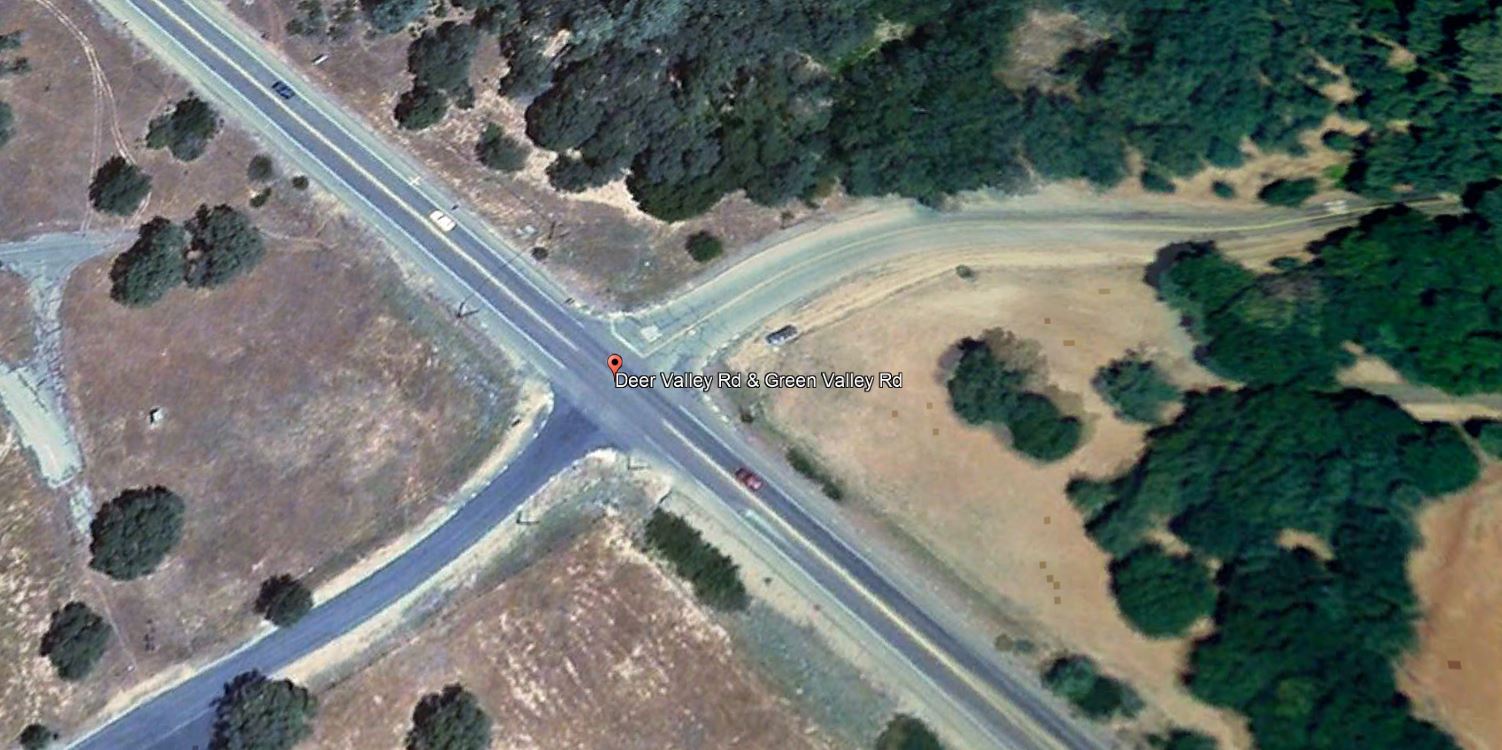
25. The applicant shall signalize the Green Valley/ Deer Valley Road intersection to meet current El Dorado County Standards, as required in the approved traffic study. These Required improvements shall include the geometric improvements to Green Valley Road consistent with the approved improvements plans for CIP Project No. 66114 which includes the intersection widening to provide for right and left tum channelization and acceleration/deceleration lanes and shall adhere to the latest version of the Manual Uniform Traffic Control Devices (MUTCD), the California Supplement, and the Caltrans Highway Design Manual. The improvements shall be substantially completed to the approval of the Department of Transportation or the applicant shall obtain an approved improvement agreement with security, prior to the filing the final map.
From the Applicant’s Application Packet to revise the project tentative map conditions of approval:
During the review of the Dixon Ranch project traffic analysis, County Staff discovered a change in the traffic warrant situation in the area. On August 16, 2018 Staff directed the applicant’s consulting engineer to reevaluate the traffic signal warrants associated the intersection of Green Valley and Deer Valley Roads. The applicant’s consulting engineer (Kimley Horn) completed a traffic signal warrant evaluation on March 28, 2019, updated June 4, 2021. Results of these analysis confirm that installation of a traffic signal at this location is not warranted at this time. Further, street improvements were recently completed at the subject intersection. This significantly improved the situation since the 2007 report. Please see attached traffic signal evaluation reports completed by Kimley Horn. Because the traffic warrant for the signalization of the intersection is not satisfied, Staff directed the consulting engineer determined this project’s fair share contribution as part of the analysis. The applicant’s fair share has been calculated at 3.9%.
Section 66498.2 of the California Subdivision Map Act allows for the amendment of a tentative map in the event of a change to an ordinance, policy, or standard. The required street widening improvements have been completed. The completion of these street improvements effectively satisfies the street improvement portion of the requirement. In deciding if a traffic signal will be an asset rather than a potential liability, traffic engineers evaluate accepted warrants for traffic signals, in this case using the California Traffic Manual Uniform Traffic Control Devices. The installation of a traffic signal should be considered if one or more of the warrants in the referenced manual is met. The decision to install a traffic signal should not be based solely upon the warrants, since the installation of a traffic signal may increase certain types of collisions, and increase delays to pedestrians, bicyclists and drivers who use the intersection. The California Manual on Uniform Control Devices criteria per the requirement were applied in the Kimley Horn analysis and warrants for the following were not met: • Warrant 1: Eight-Hour Vehicular Volume • Warrant 2: Four-Hour Vehicular Volume • Warrant 3: Peak Hour • Warrant 4: Pedestrian Volumes
The projected traffic volumes that would have warranted a traffic signal have not materialized. Although the standard has not changed, the standard has not been met as projected. In fact, the installation of a signal at this location could create an unsafe situation. At Staffs request an updated traffic warrant study was undertaken which resulted in warrants not being met. Because warrants have not been met, the applicant requests the tentative map be amended modifying Condition No. 25 to eliminate the installation of a signal by the applicant and require the applicant pay the project’s fair share cost of the signal.
Fair Share: The Kimley Horn traffic signal warrant evaluation determined that the project’s fair share contribution to the signal is 3.90% or an estimated $10,000-$12,000. The applicant has contracted with Kimley Horn to design traffic signal construction plans for the intersection of Deer Valley /Green Valley. The plans will allow the traffic signal to be built at the time warrants are met. The applicant proposes that these plans be used to satisfy the project’s fair share of the signal costs. In fact, the actual contracted cost for the signal design ($17,000) exceeds the applicant’s fair share cost for the traffic signal.
Request: Blue Mountain Communities requests modification to TM07-1440-R-2 Department of Transportation condition 25. Specifically, we request that Condition No. 25 be modified such that the applicant/owner be required to contribute its fair share to the subject traffic improvements as detailed in the traffic signal warrant evaluations prepared by Kimley Horn and attached hereto. Further, its is requested that the traffic signal design plans being prepared by Kimley Horn for Blue Mountain Communities serve as Blue Mountain’s fair share contribution.
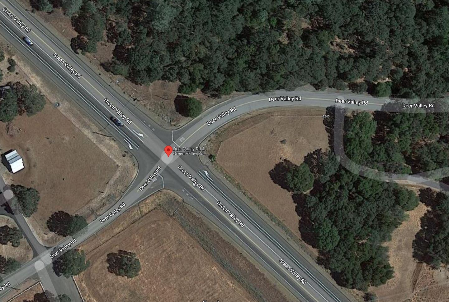
Improvements to the Green Valley Road – Deer Valley Road intersection were completed in 2014 along with the addition of the Green Valley Road – Silver Springs Parkway Intersection/signalization project, conditioned by the approval of the Silver Springs residential development , which satisfied elements of CIP Project No. 66114 which included the intersection widening to provide for right and left tum channelization and acceleration/deceleration lanes.
Green Valley Road at Deer Valley Road (west) satellite image from 2008 when the Summer Brook Project was approved by the Board of Supervisors
Green Valley Road at Deer Valley Road (west) satellite image from 2021, following widening, and turn pocket improvements from 2014
Blue Mountain Communities purchased the Summer Brook property in 2021, and are currently developing the approved 29 residential lots. They also purchased the Silver Springs property across Green Valley Road in 2018, and are currently developing 37 homes in phase 1 of the Revere at Silver Springs project.
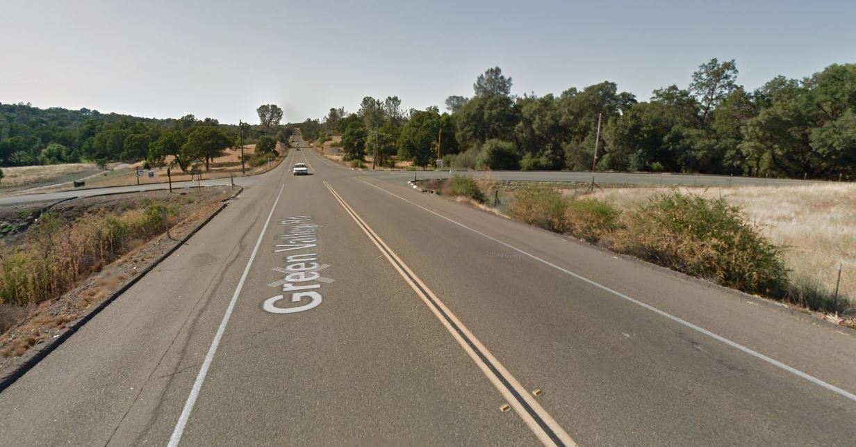
Green Valley Road looking west towards the Deer Valley Road (west) intersection in 2012, prior to road improvements in 2014
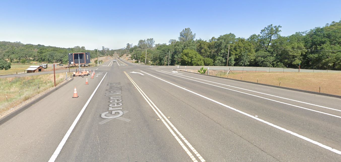
Green Valley Road looking west towards the Deer Valley Road (west) intersection in 2021, following road improvements in 2014
Over-optimistic growth/planning projections, and road improvements lost
Bass Lake Area residents in Rescue, Cameron Park, and El Dorado Hills, will notice a pattern – planned and promised road and pedestrian circulation and safety improvements, conditioned by multiple development applications from over 30 to 20 years ago, being delayed or removed from the County’s list of projects, primarily based on inaccurate analysis and projections from the late 1980s, the 1990s, and the 2000 – 2015 era. Frustratingly for area residents is that the analysis of multiple development projects resulted in findings regarding impacts on our communities from twenty, and even thirty-plus years ago had provided the blueprint for the growth of the Bass Lake Area, but the analysis, findings, and mitigations continue to unravel. Multiple projects over those many years were approved with the assumptions of cumulative impacts between them all, and intertwined conditions of approval. Recent analysis of these projects as they are revisited have led to many improvement projects disappearing from the planning horizon:
The removal of CIP projects for constructing a four lane Bass Lake Road in 2015, and 2016
The removal of frontage improvements (Sidewalks, turn pockets, and bicycle lanes) for Bass Lake Road provided by specific projects in the 1988 El Dorado Hills Specific Plan, as those projects were updated in 2017 and 2019
Removal of planned elements of Bass Lake Road improvements included in the 1996 Bass Lake Hills Specific Plan, in 2016-17.
Removal of four lane Bass Lake Road improvements from US50 to Serrano Parkway attributed to a finding that Bass Lake Road from the re-aligned Country Club Drive north to Serrano Parkway exists in the El Dorado Hills Community Region, and Bass Lake Road from Country Club Drive south to US50 exists in the County Rural Region in 2019-20 – Level of Service (LOS) metrics/triggers differ between community and rural regions.
Public Comments regarding TM-R21-0001
If you would like to provide public comments to the Planning Commission prior to the April 14, 2022 hearing, you can submit fact based informed comments to planning@edcgov.us . Remember, emotion is not part of the deliberative process of the Planning Commission, so respectful comments, related to your concerns or questions, make for the most productive discussion.