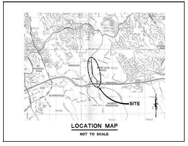
The Cameron Park Design Review Committee gets its first look at a proposed Mc Donald’s restaurant, along with an ARCO AM/PM gas station & convenience store, and a Quick Quack Car Wash, as a new phase of the Green Valley Station shopping center, near the Grocery Outlet store on the south side of Green Valley Road between Cambridge Drive and Cameron Park Drive.
The Cameron Park DRC will take an initial look at the Pre Applications for the proposed development at their scheduled July 22, 2024 meeting. Pre application PA24-0001 for all three developments was submitted January 31, 2024.
Both the Mc Donald’s and the ARCO AM/PM projects are indicated to operate 24 hours a day.
Project Parking
The Mc Donald’s project specifies that it will provide 22 parking stalls, with 4 for EV charging – with one for an EV Van, and 2 Accessible stalls. El Dorado County Zoning Ordinance indicates that based on floor space of the Quick Serve facility, that the parking requirements should be 17 total stalls – 4 EV, and 2 Accessible.
The ARCO AM/PM will provide 26 parking stalls (12 fueling, 4 EV, and 10 standard stalls). El Dorado County Zoning Ordinance indicates that based on floor space the ARCO AM/PM project is required to provide 20 parking stalls.
The Quick Quack Car Wash will provide 54 parking stalls – 30 wash stacking lane spots, 3 standard parking stalls, and 21 vacuum parking stalls.
Cameron Park Design Review Meeting July 22, 2024 6:30PM
The Cameron Park DRC meeting is scheduled for July 22 at 6:30PM in person at the Shingle Springs Cameron Park Chamber of Commerce, 4095 Cameron Park Drive Cameron Park, CA 95682 OR Live Streamed via zoom https://edcgov-us.zoom.us/j/96425149671
100 Space Park & Ride Lot Required As Condition of Approval of the 90 home Bass Lake North project.
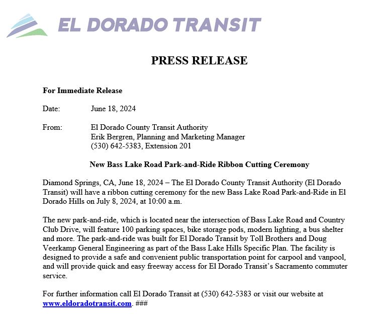
El Dorado Transit has scheduled a ribbon cutting ceremony for July 8th at 10am to celebrate the opening of the 100 parking space Bass Lake Road Park & Ride, located at the south west corner of Bass Lake Road-Country Club Dr intersection, on Old Bass Lake Road.
The park & ride lot will officially open for service on Monday July 15th. All commuter stops at Cambridge Park & Ride will move to Bass Lake Road Park & Ride.
The park & ride lot was an element of the 1996/2016 Bass Lake Hills Specific Plan. The entitlements granted to the 2017 approved 90 home Bass Lake North residential project in the Bass Lake Hills Specific Plan required as a condition of approval the construction of the first 100 parking spaces of what was intended to eventually be a 200 parking space facility. The Bass Lake North project is now known as the Toll Brothers’ Hidden Ridge development.
The park & ride lot is expected to be used for carpool and vanpool riders, as well as for El Dorado Transit’s Sacramento Commuter Service. It is expected to lessen the demand at the Town Center Park & Ride lot in El Dorado Hills, which is over-impacted.
The park & ride lot is also available for parking to access the future trail system in the Bass Lake Hills Specific Plan area, with connectivity to trails in the Serrano area, as well as bike trails east into Cameron Park.
It is expected that the El Dorado County Household Hazardous Waste collection events that have been held at El Dorado Hills Fire Station 86 on Bass Lake Road will now be conducted at the Bass Lake Road Park and Ride facility.
For more information, contact El Dorado Transit at 530 642-5383, or online at eldoradotransit.com
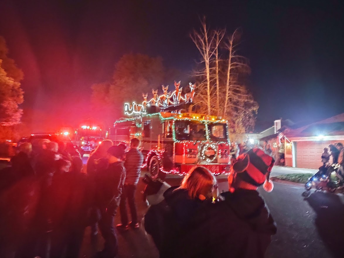
Santa Arrives in the Bass Lake Area at 6PM on Thursday December 8th!
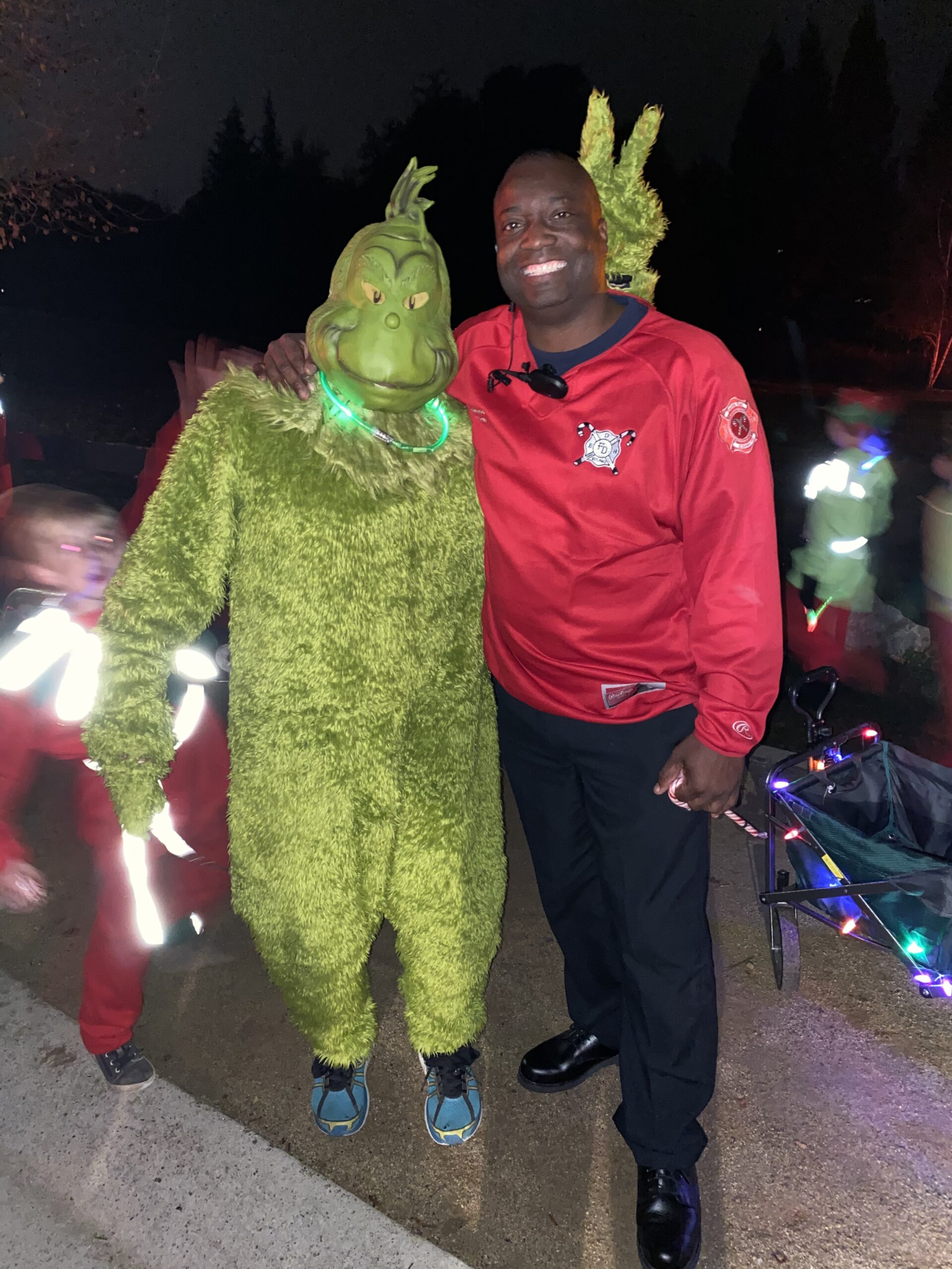
Bass Lake Area Neighbors, are you ready for Santa’s HOLIDAY HEROES visit this Thursday December 8th? Santa and his El Dorado Hills Fire Department Elves will be collecting unwrapped toys, non-perishable food and letters to Santa at each of the planned Santa Stops. Toys collected will be donated to the Shriners’ Hospital for Children of Northern California, and non-perishable food donations will go to the Foodbank of El Dorado County. Last year Santa and his EDH Fire Dept Elves collected 7,800 toys and 4,836 pounds of food!
In the Bass Lake Area, Santa will be stopping at Oak Knoll Park at approximately 6PM. Following this, Santa and his elves will head over to stop at the Bridlewood Canyon Clubhouse and Visitor Center at 6:35PM. To finish up the night, Santa’s last Bass Lake Area Stop will be at Laurel Oaks Park at 7:10PM.
Remember, even though we’re all excited to see Santa arrive along with all of the EDH Fire Department engines, trucks, and sirens, let’s make sure that the kidos stay safe and out of the street until all fire department equipment has stopped.
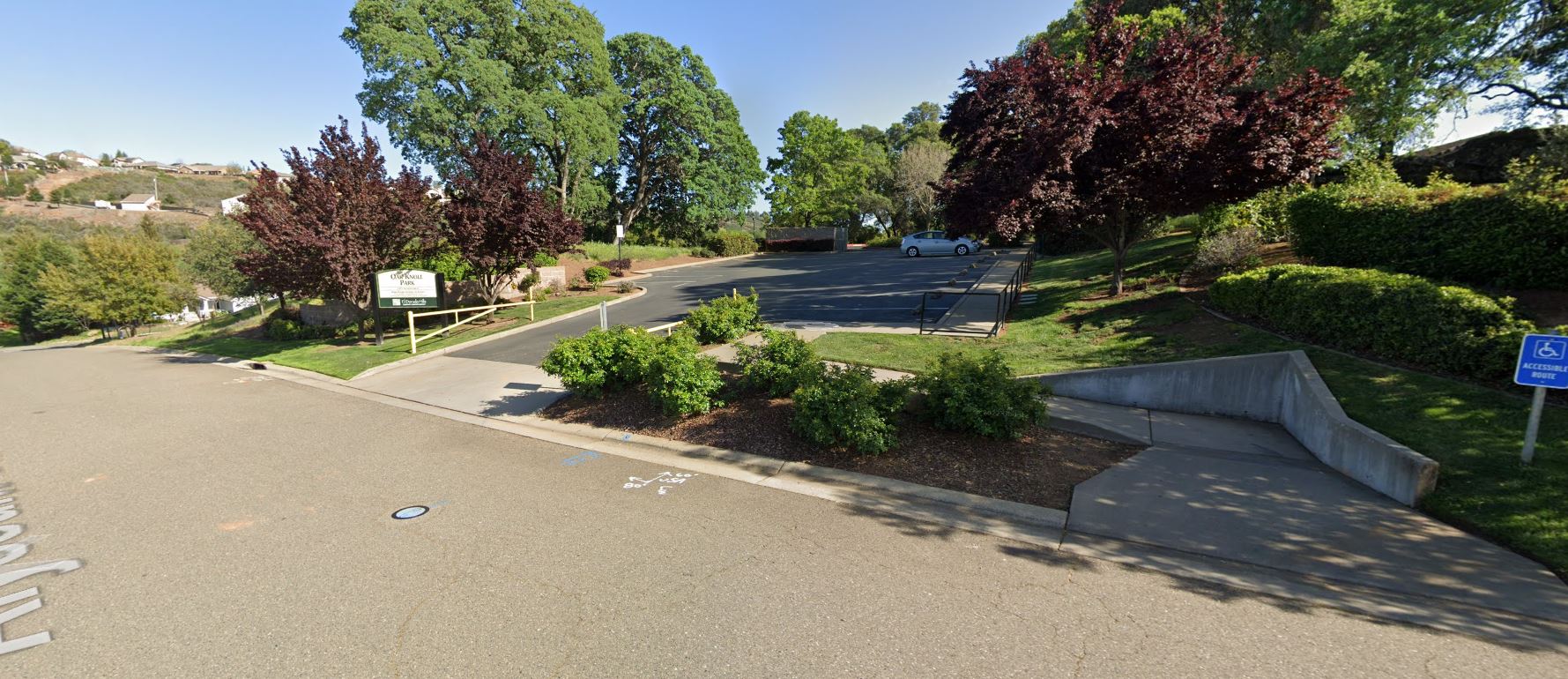
2021 Santa Run at Oak Knoll Park
Want to grab a photo with Santa and Mrs. Claus? Changes for 2022
We’ve heard from the EDH Fire Dept Elves that Santa has been eating healthy and has had a BIG growth spurt this year! Santa is coming in at about 6 feet 7 inches this year!!! – So when Santa and Mrs. Claus take pictures with the Kids this year, at the Oak Knoll Park Santa Stop, Santa and Mrs. Claus will be seated in front of the Oak Knoll Park parking lot driveway – this will help keep Santa and Mrs. Claus centered in photos with the Kids!!! Santa’s Elves have asked the everyone wanting to take photos with Santa and Mrs. Claus to line up in the Oak Knoll Park parking lot – don’t worry, everyone will get their pictures with Santa!
Santa’s Elves and maybe even The Grinch will be handing out Candy Canes as well!
We’ll have chairs ready for Santa and Mrs. Claus, plus a small table to drop off toy and food donations, as well as any Letters for Santa that need to be delivered.
Line up in the Parking Lot here for photos with Santa!!!
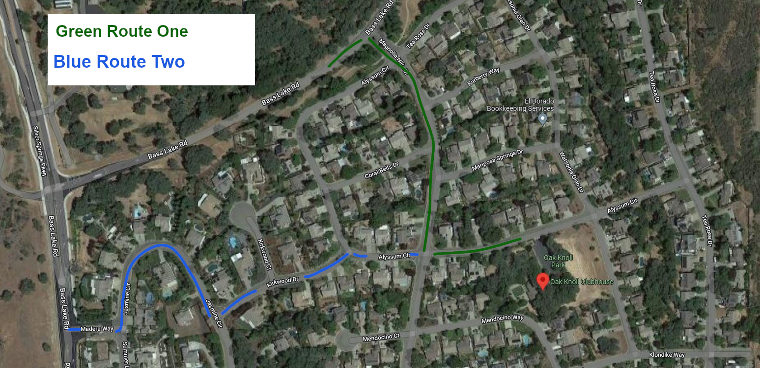
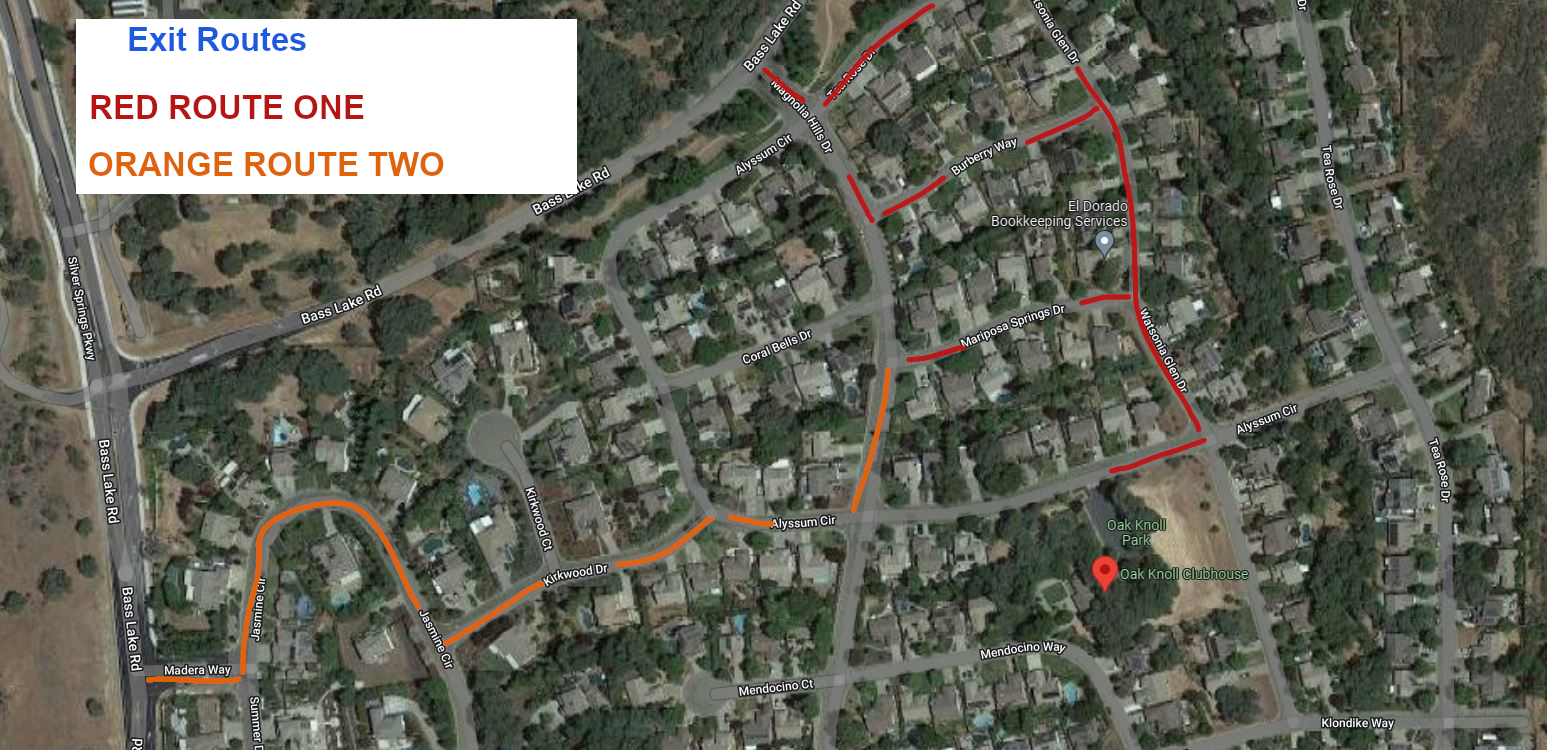
Santa’s Flight Path to Oak Knoll Park
Santa’s expected flight path to Oak Koll Park is expected to bring the Fire Engines and trucks from Bass Lake Road, onto Magnolia Hills Drive, then onto Alyssum Circle to Oak Knoll Park. When Santa leaves, the flight path is expected to head down Watsonia Glen Drive to Tea Rose Drive, and then back to Bass Lake Road to head to Bridlewood Canyon, and later to Laurel Oaks Park. We were out with Santa’s Elves pre-flighting the route on Friday, and we discovered that the powerlines on Bass Lake Road at Magnolia Hills Drive are very low, and Santa’s sleigh is sitting a bit higher on the EDH Fire Engine this year – also, the oak trees in the greenbelt along Tea Rose Drive are very, very low this year – so Santa’s flight path might instead be changed by air traffic controllers after they check the route one more time and bring Santa in from Bass Lake Road on Madera Way, Jasmine Circle, and then up Kirkwood Drive to Alyssum Circle, and when he leaves he may cut over from Watsonia Glen Drive on Burberry Way, or Mariposa Springs – so make sure that roads stay clear for Santa’s take-off!
Flight path into Oak Knoll Park: Green Primary Route – Blue Alternate Route
Departure Flight paths from Oak Knoll Park
Remember – let’s try to keep out of our neighbors’ yards, while also keeping the street clear for Santa and the EDH Fire Department.
The Grinch along with El Dorado Hills Fire Department Chief Maurice Johnson
Let’s show Santa that we’re ready to help the Holiday Heroes Food and Toy Drive on Thursday night!!!
Analysis suggests that anticipated traffic volume increases have not materialized after 15 years.
A El Dorado County Land Use and Dev Services Public Notice has notified El Dorado County residents of a planned hearing before the County Planning Commission on April 14, 2022.
The County of El Dorado Planning Commission will hold a public hearing in the Planning Commission Hearing Room, 2850 Fairlane Court, Placerville, CA 95667 on April 14, 2022, at 8:30 a.m., to consider the following: Tentative Subdivision Map Revision TM-R21-0001/Summer Brook submitted by BLUE MOUNTAIN COMMUNITIES, INC., request for a revision to the approved Summer Brook Tentative Map and Planned Development TM07-1440/PD07-0007 to remove Conditions of Approval No. 25, 27 and 28 requiring installation of a traffic signal and completion of, or financing for, associated intersection improvements prior to final map recordation. In lieu of a financial contribution, the applicant may instead propose the submittal of construction documents for the signal and which support construction by others once a signal warrant analysis justifies installation
Condition of approval #25 from the March 11, 2008 project approval by the County Board of Supervisors:
25. The applicant shall signalize the Green Valley/ Deer Valley Road intersection to meet current El Dorado County Standards, as required in the approved traffic study. These Required improvements shall include the geometric improvements to Green Valley Road consistent with the approved improvements plans for CIP Project No. 66114 which includes the intersection widening to provide for right and left tum channelization and acceleration/deceleration lanes and shall adhere to the latest version of the Manual Uniform Traffic Control Devices (MUTCD), the California Supplement, and the Caltrans Highway Design Manual. The improvements shall be substantially completed to the approval of the Department of Transportation or the applicant shall obtain an approved improvement agreement with security, prior to the filing the final map.
From the Applicant’s Application Packet to revise the project tentative map conditions of approval:
During the review of the Dixon Ranch project traffic analysis, County Staff discovered a change in the traffic warrant situation in the area. On August 16, 2018 Staff directed the applicant’s consulting engineer to reevaluate the traffic signal warrants associated the intersection of Green Valley and Deer Valley Roads. The applicant’s consulting engineer (Kimley Horn) completed a traffic signal warrant evaluation on March 28, 2019, updated June 4, 2021. Results of these analysis confirm that installation of a traffic signal at this location is not warranted at this time. Further, street improvements were recently completed at the subject intersection. This significantly improved the situation since the 2007 report. Please see attached traffic signal evaluation reports completed by Kimley Horn. Because the traffic warrant for the signalization of the intersection is not satisfied, Staff directed the consulting engineer determined this project’s fair share contribution as part of the analysis. The applicant’s fair share has been calculated at 3.9%.
Section 66498.2 of the California Subdivision Map Act allows for the amendment of a tentative map in the event of a change to an ordinance, policy, or standard. The required street widening improvements have been completed. The completion of these street improvements effectively satisfies the street improvement portion of the requirement. In deciding if a traffic signal will be an asset rather than a potential liability, traffic engineers evaluate accepted warrants for traffic signals, in this case using the California Traffic Manual Uniform Traffic Control Devices. The installation of a traffic signal should be considered if one or more of the warrants in the referenced manual is met. The decision to install a traffic signal should not be based solely upon the warrants, since the installation of a traffic signal may increase certain types of collisions, and increase delays to pedestrians, bicyclists and drivers who use the intersection. The California Manual on Uniform Control Devices criteria per the requirement were applied in the Kimley Horn analysis and warrants for the following were not met: • Warrant 1: Eight-Hour Vehicular Volume • Warrant 2: Four-Hour Vehicular Volume • Warrant 3: Peak Hour • Warrant 4: Pedestrian Volumes
The projected traffic volumes that would have warranted a traffic signal have not materialized. Although the standard has not changed, the standard has not been met as projected. In fact, the installation of a signal at this location could create an unsafe situation. At Staffs request an updated traffic warrant study was undertaken which resulted in warrants not being met. Because warrants have not been met, the applicant requests the tentative map be amended modifying Condition No. 25 to eliminate the installation of a signal by the applicant and require the applicant pay the project’s fair share cost of the signal.
Fair Share: The Kimley Horn traffic signal warrant evaluation determined that the project’s fair share contribution to the signal is 3.90% or an estimated $10,000-$12,000. The applicant has contracted with Kimley Horn to design traffic signal construction plans for the intersection of Deer Valley /Green Valley. The plans will allow the traffic signal to be built at the time warrants are met. The applicant proposes that these plans be used to satisfy the project’s fair share of the signal costs. In fact, the actual contracted cost for the signal design ($17,000) exceeds the applicant’s fair share cost for the traffic signal.
Request: Blue Mountain Communities requests modification to TM07-1440-R-2 Department of Transportation condition 25. Specifically, we request that Condition No. 25 be modified such that the applicant/owner be required to contribute its fair share to the subject traffic improvements as detailed in the traffic signal warrant evaluations prepared by Kimley Horn and attached hereto. Further, its is requested that the traffic signal design plans being prepared by Kimley Horn for Blue Mountain Communities serve as Blue Mountain’s fair share contribution.
Improvements to the Green Valley Road – Deer Valley Road intersection were completed in 2014 along with the addition of the Green Valley Road – Silver Springs Parkway Intersection/signalization project, conditioned by the approval of the Silver Springs residential development , which satisfied elements of CIP Project No. 66114 which included the intersection widening to provide for right and left tum channelization and acceleration/deceleration lanes.
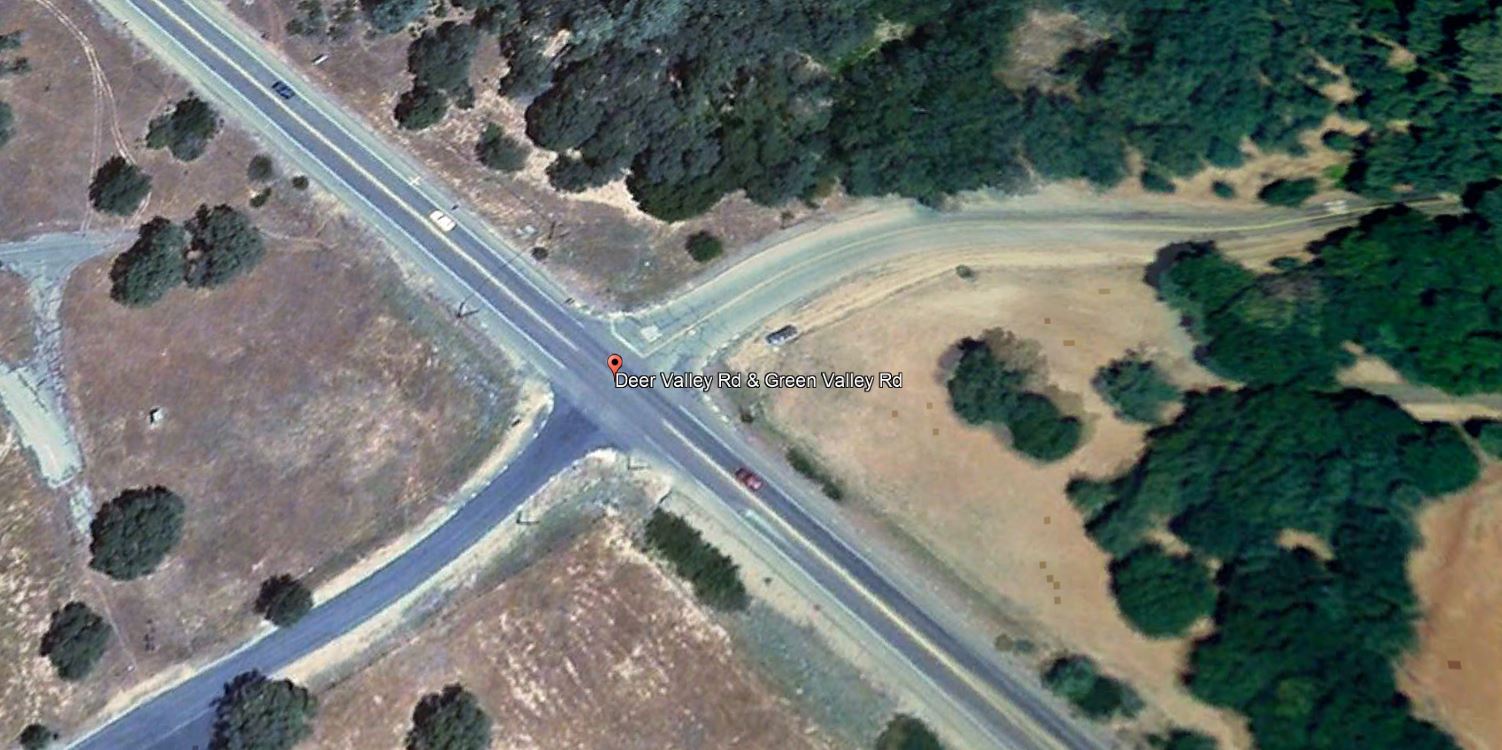
Green Valley Road at Deer Valley Road (west) satellite image from 2008 when the Summer Brook Project was approved by the Board of Supervisors
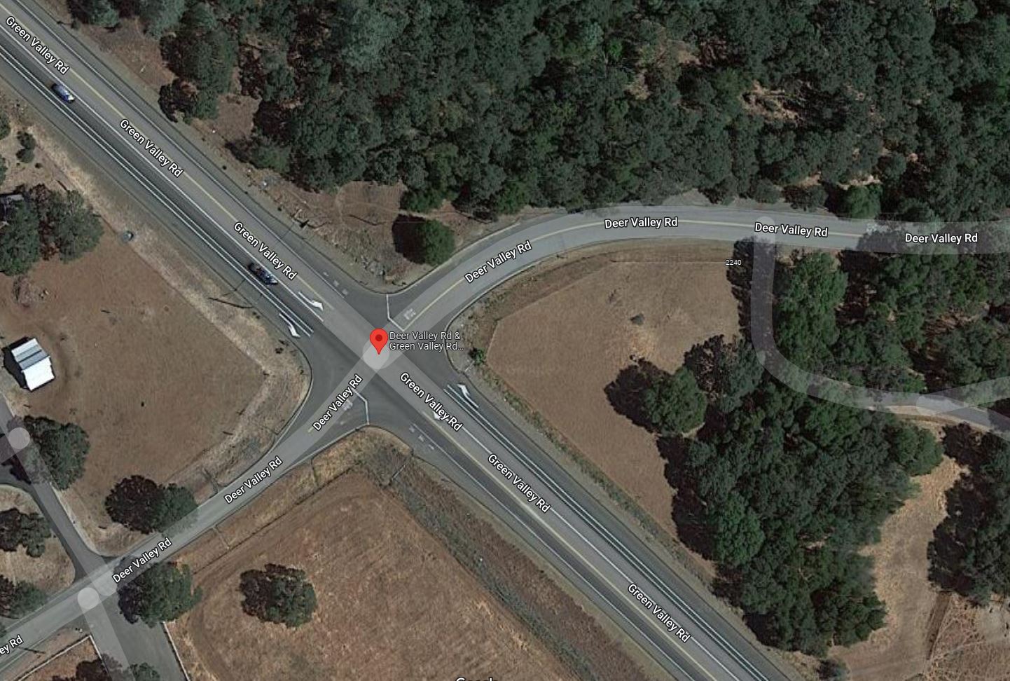
Green Valley Road at Deer Valley Road (west) satellite image from 2021, following widening, and turn pocket improvements from 2014
Blue Mountain Communities purchased the Summer Brook property in 2021, and are currently developing the approved 29 residential lots. They also purchased the Silver Springs property across Green Valley Road in 2018, and are currently developing 37 homes in phase 1 of the Revere at Silver Springs project.
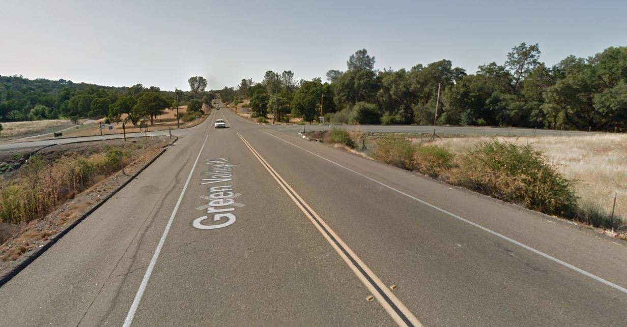
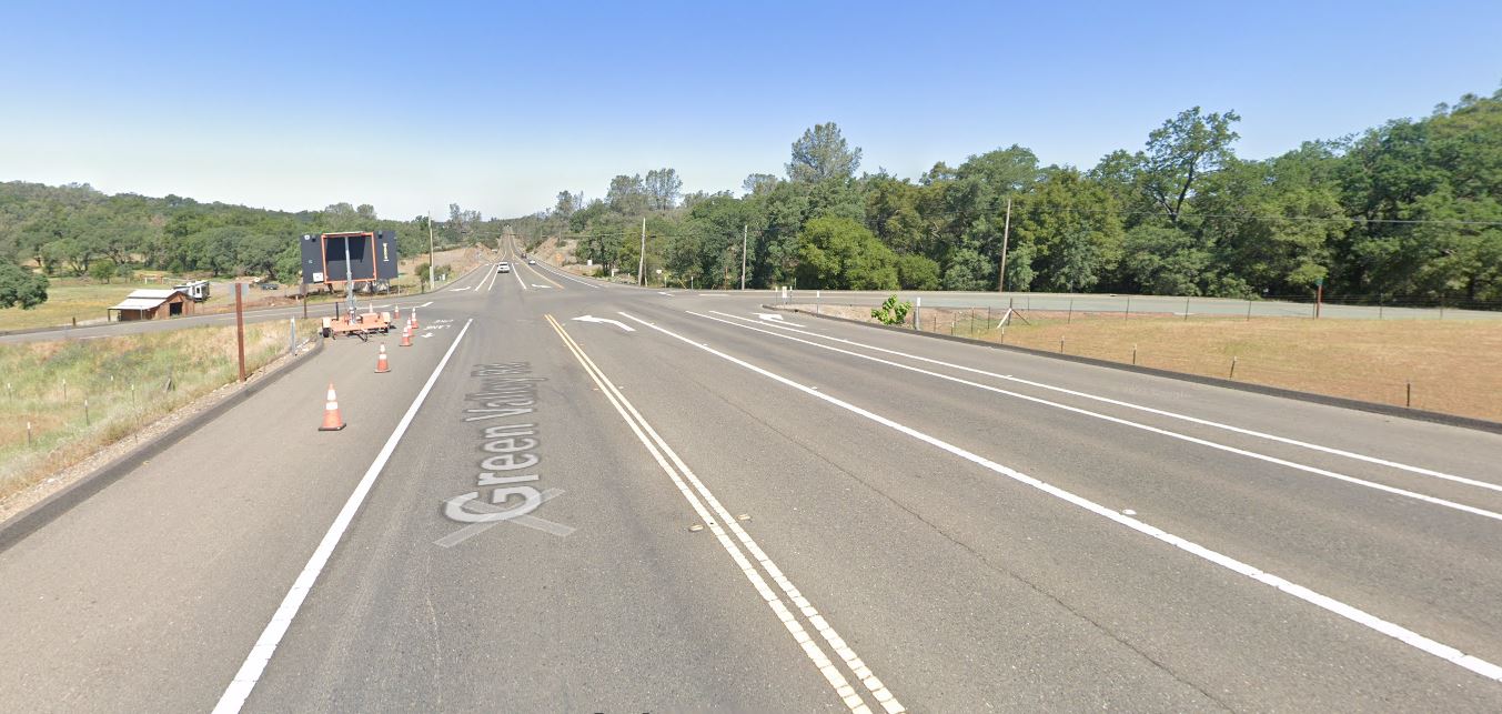
Green Valley Road looking west towards the Deer Valley Road (west) intersection in 2012, prior to road improvements in 2014
Green Valley Road looking west towards the Deer Valley Road (west) intersection in 2021, following road improvements in 2014
Over-optimistic growth/planning projections, and road improvements lost
Bass Lake Area residents in Rescue, Cameron Park, and El Dorado Hills, will notice a pattern – planned and promised road and pedestrian circulation and safety improvements, conditioned by multiple development applications from over 30 to 20 years ago, being delayed or removed from the County’s list of projects, primarily based on inaccurate analysis and projections from the late 1980s, the 1990s, and the 2000 – 2015 era. Frustratingly for area residents is that the analysis of multiple development projects resulted in findings regarding impacts on our communities from twenty, and even thirty-plus years ago had provided the blueprint for the growth of the Bass Lake Area, but the analysis, findings, and mitigations continue to unravel. Multiple projects over those many years were approved with the assumptions of cumulative impacts between them all, and intertwined conditions of approval. Recent analysis of these projects as they are revisited have led to many improvement projects disappearing from the planning horizon:
The removal of CIP projects for constructing a four lane Bass Lake Road in 2015, and 2016
The removal of frontage improvements (Sidewalks, turn pockets, and bicycle lanes) for Bass Lake Road provided by specific projects in the 1988 El Dorado Hills Specific Plan, as those projects were updated in 2017 and 2019
Removal of planned elements of Bass Lake Road improvements included in the 1996 Bass Lake Hills Specific Plan, in 2016-17.
Removal of four lane Bass Lake Road improvements from US50 to Serrano Parkway attributed to a finding that Bass Lake Road from the re-aligned Country Club Drive north to Serrano Parkway exists in the El Dorado Hills Community Region, and Bass Lake Road from Country Club Drive south to US50 exists in the County Rural Region in 2019-20 – Level of Service (LOS) metrics/triggers differ between community and rural regions.
Public Comments regarding TM-R21-0001
If you would like to provide public comments to the Planning Commission prior to the April 14, 2022 hearing, you can submit fact based informed comments to planning@edcgov.us . Remember, emotion is not part of the deliberative process of the Planning Commission, so respectful comments, related to your concerns or questions, make for the most productive discussion.
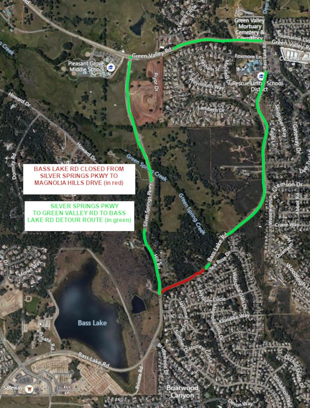
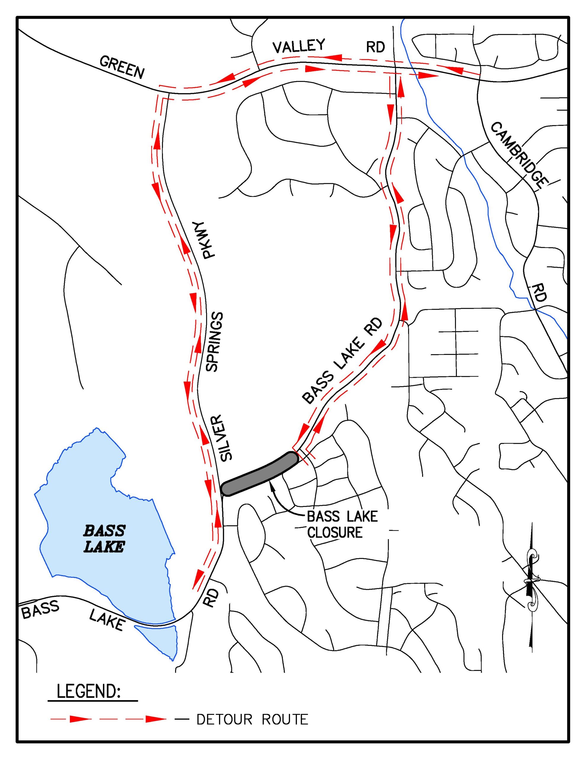
Detour available via Silver Springs Parkway & Green Valley Road
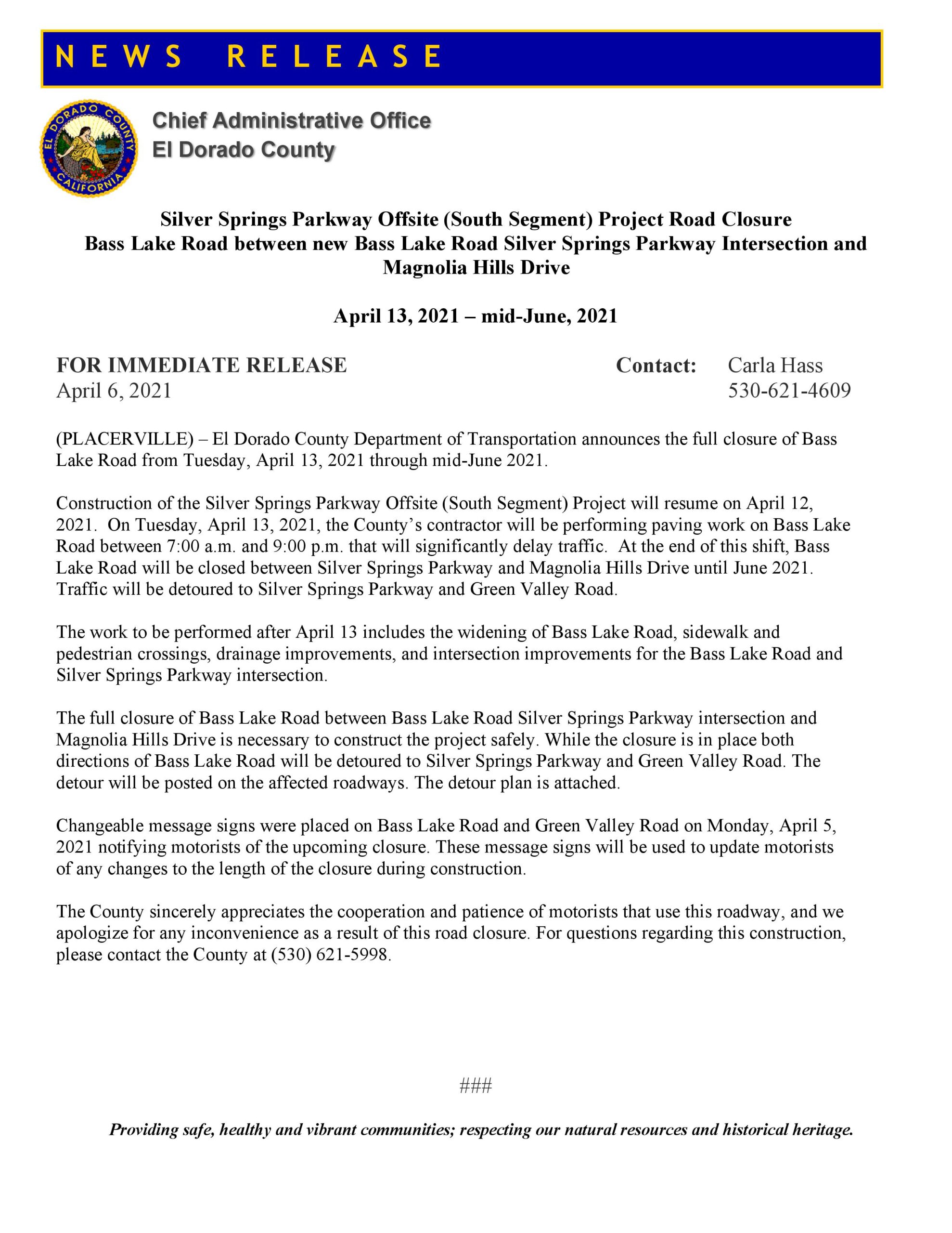
El Dorado County has announced the planned closure of Bass Lake Road at the new Silver Springs Parkway intersection just north of Madera Way in El Dorado Hills, beginning April 13, 2021, and will last through mid June 2021.
The closure will be in place between the new Silver Springs Parkway connection at the 25 MPH curve on Bass Lake Rd (Sandhurst Hill Rd) east to Magnolia Hills Drive.
On April 13th, crews from Granite Construction will spend the day paving the the new Silver Springs Parkway connection to Bass Lake Road – when the paving activity is completed on April13th, Silver Springs Parkway will be opened to motorists between Madera Way and Green Valley Road. This is the planned Detour route while Bass Lake Road is closed.
Per El Dorado County Department of Transportation, residents and motorists should expect significant and long delays on Bass Lake Road on April 13th, while the paving work is completed.
Planned Detour Route in Green – Bass Lake Road closure in Red
While Bass Lake Road is closed from Silver Springs Parkway to Magnolia Hills Drive, construction crews will realign Bass Lake Road and construct an ADA compliant sidewalk and crosswalks on Bass Lake Road at the new intersection. Southbound Bass Lake Road will be constructed with left and right turn lanes – the left lane will be for motorists traveling south on Bass Lake Road towards US50, the right turn lane will allow motorists to continue north onto Silver Springs Parkway, towards Green Valley Road. Northbound Bass Lake Road at the new Silver Springs intersection will feature a straight through lane to continue north on Silver Springs Parkway towards Green Valley Road, as well as a right turn pocket for motorists to continue north on Bass Lake Road towards Magnolia Hills Drive, Woodleigh Lane, Gateway Drive, Lambeth Drive, Parkdale Lane, Foxmore Lane, and Green Valley Road.
Silver Springs Parkway will be a divided two lane roadway, with sidewalks and bicycle lanes.
The new Bass Lake Road-Silver Springs Parkway intersection will be a three-way stop sign controlled intersection.
Changeable Portable Reader Board signage will be in place to advise motorists of changing conditions and delays. Currently the changeable portable reader boards indicate that the closure is expected to be in place from April 13th through June 11th – the completion date is subject to change due to weather delays, and possible utility relocation delays from PG&E and AT&T.
Bass Lake North 90 home subdivision appeal hearing at the Board of Supervisors Dec 8th
The Bass Lake North project was approved in 2017 by the Board of Supervisors – it is located in the Bass Lake Hills Specific Plan area, along Sienna Ridge Road just south and east of the Sienna Ridge Shopping Center.
One of the conditions of approval in 2017, Condition of Approval 66 (COA 66) was that the project would build 100 vehicle spaces of the eventual 200 space Park and Ride facility that will be located on the south west side of the new Bass Lake Road – Country Club Drive signalized intersection. Ten of the proposed spaces are also considered for use in the eventual Mormon Carson Trail system in the Plan Area.
The Developer filed a request to reduce his obligation of 100 spaces to 50 spaces, and move the responsibility for the remaining 50 spaces to an undefined “future” development in the BLHSP Plan Area – meaning the next project would have to build the other 50 spaces. His request was based on the significant costs to build the Park and Ride spaces, and his determination that his 90 home project was being unfairly burdened with an excessive share of the Park and Ride Lot costs. During the public hearing, the developer also provided his own nexus analysis of the need for park and ride spaces in the area based on his status as a licensed civil engineer in California – his determination was that the full build out of the entire Bass Lake Hills Specific Plan area would only generate the need for a little more than 11 total park and ride spaces, and that his project specifically would only generate the need for less than four spaces.
The request also sought to have the option of paying El Dorado Transit Authority for “in lieu fees” instead of even building just the 50 parking spaces.
After three hours of testimony at the Nov 12th Planning Commission Hearing, the Planning Commission voted 3-2 to deny the change request. The Developer has filed an appeal of the Planning Commission denial with the El Dorado County Board of Supervisors, with the hearing scheduled for December 8th.
The Bass Lake North Project is also required via Condition of Approval 67 (COA 67) to build a segment of Class 1 bicycle lane from the old Country Club Drive intersection to the end of the existing bicycle lane along Bass Lake Road at Hollow Oak Road. This was a Board of Supervisors-added condition of approval at the project hearing in February 2017. The Developer agreed to the Park and Ride Construction, and the Class 1 Bicycle lane construction.
The Developer suggested during the Nov 12th Planning Commission Hearing that the Class 1 Bicycle lane was a last minute add-on, and considered that it was important to the District 2 Supervisor, and was more valuable to the community than the full 100 spaces of the Park and Ride Lot. Hinting that the end result could be a choice of providing a 50 space Park and Ride Lot and a Class 1 Bicycle Lane, or just the 100 spaces of the Park and Ride Lot, with no Class 1 Bicycle Lane.
It is important to remind the Board of Supervisors that they are not under any obligation to accommodate the Developer’s request: The entitlements for the approved project requires BOTH construction of 100 spaces of the Park and Ride Lot, and the Class 1 Bicycle Lane. There is no need to trade parts of one COA for another. The Park and Ride Lot Construction costs will be fully refundable to the applicant through the Public Facilities Financing Plan (PFFP) of the Bass Lake Hills Specific Plan.
At the Nov 12th Planning Commission Hearing, the El Dorado Hills APAC offered one of only two public comments on the project request (here), asking the Planning Commission to deny the change request.
More resident public comments could improve the chances that the Board of Supervisors will reject the appeal, and require the developer to construct both the 100 spaces of the Park and Ride Lot, as well as the Class 1 Bicycle Lane, as originally intended by the project conditions of approval. Even just emailing in a form letter may make the difference.
The history of Bass Lake Road development is replete with after-the-fact-changes to approved projects and planned improvements – which is why Bass Lake Road had three long scheduled Capital Improvement Plan (CIP) projects removed in 2016 from the CIP project list:
In fact, at the Nov 17, 2020 Board Of Supervisors hearing regarding the 2020 TIM fee program update, the Transportation Dept. Director told the County Supervisors that Bass Lake Road was unlikely to be getting these improvements back on the CIP list in the 20 year horizon, because conditions (traffic volume, and road conditions) were not projected to warrant the improvements.
Public comments can be emailed to the Clerk of the Board of Supervisors by Monday December 7th. Getting public comments in before the close of business will ensure that the comments are seen by the Supervisors prior to the hearing. Comments should be respectful, and fact based, and not depend on emotion, which tends to get ignored.
Would you consider submitting public comments on the Bass Lake North Appeal hearing?
Sample Form Letter – copy and paste into your own email message to the Board of Supervisors:
COPY and PASTE the sample letter below andemail to: edc.cob@edcgov.us
SUBJECT: Denial of Tentative Subdivision Map Revision TM-R19-0002 Bass Lake North
Dear Supervisors,
I ask that you uphold the Planning Commission’s November 12, 2020 denial of the Tentative Subdivision Map Revision TM-R19-0002 Bass Lake North request to revise the Condition of Approval #66 that sought to reduce the required constructed quantity of park-and-ride parking spaces from 100 to 50 and phasing the remaining 50 spaces as a Condition of Approval for future subdivision(s) within the Bass Lake Hills Specific Plan area.
The Planning Commission’s reasons for denial were:
No technical analysis or justification was presented to support the applicant’s request;
The El Dorado Transit Master Plan, testimony from the Transit Authority and Public Comment shows a need for the Park-and-Ride spaces and the Transit Authority Board has not vetted any technical analysis for this request;
These projects (Park-and-Ride spaces) are going to be fully refundable to the applicant through the Public Facilities Financing Plan (PFFP);
The intention of the Bass Lake Hills Specific Plan was to front load the needed infrastructure;
The assertion that it would be reasonable to push the requirement of the additional 50 Park-and-Ride spaces to potential future projects (potentially smaller future projects) would be unfair to those future projects and applicants;
The applicant agreed to the front loading infrastructure as approved and conditioned by the Planning Commission, and the Board of Supervisors additional condition of approval to include a bike path; and,
The current approved project is more consistent with the Bass Lake Hills Specific Plan and the County General Plan than the proposed modified request as presented to the Planning Commission.
Changes to anticipated traffic levels, build out projections, and deferring infrastructure improvements to undefined future development is how Bass Lake Road became a road with three Capital Improvement Plan projects removed in 2015/16.
The El Dorado Transit Authority had based their needs for Park and Ride lots on an analysis that predates the 2017 approval of the Bass Lake North project. El Dorado Transit Authority’s recent concession to the applicant’s request to change from 100 funded parking spaces to 50 parking spaces is not based on any meaningful analysis.
The Park and Ride is also intended to provide 10 joint use parking spaces anticipated to be used for the Mormon Carson Trail within the Bass Lake Hills Specific Plan Area.
Further, on page 107 the Bass Lake North Project CEQA Addendum and Initial Study of Environmental Significance, approved by the Board of Supervisors on February 28, 2017 specifies that development of a park and ride facility near the intersection of Bass Lake Road and Country Club Drive should be required in conjunction with the development of the area.
Also, that a portion of the Class 1 Bicycle lane from Old Country Club Drive to Hollow Oak Road had to be added to the Specific Plan and this project without analysis during the Board of Supervisors hearing in 2017, further demonstrates a lack of full consideration for the facilities and circulation elements in the 2016/17 updated Bass Lake Hills Specific Plan. The County should not be trading Conditions of Approval after the fact.
Both the Park and Ride Lot and the Bicycle lane are facilities that are lacking in the Bass Lake Area, and trading required Conditions of Approval years after the project has been approved, in deference to cost increases, does not serve the interests of residents or the County. Additionally, the park and ride facility construction costs are reimbursable to the developer.
I request that both Condition of Approval #66 (the 100 spaces in the Park and Ride Lot) and Condition of Approval #67 (the Class 1 Bicycle lanes) not be modified for this project, and that you uphold the Planning Commission Denial of the request, and refuse the appeal.
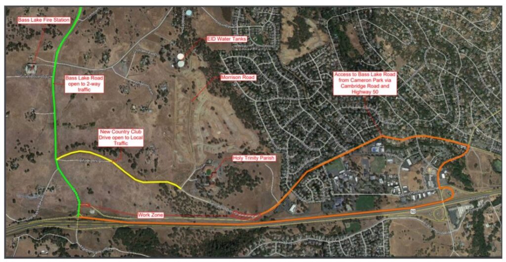
El Dorado County Issues Phase 4 Country Club Drive Detour Press Release
Beginning Friday, September 11th at 6:00 a.m. Vehicles will be directed around the intersection utilizing Bass Lake Road, New Country Club Drive, Cambridge Road, and Highway 50 from Friday, September 11th through Monday, September, 28th.
Country Club Drive from Tierra De Dios Drive to Bass Lake Road will be CLOSED.
Tierra De Dios Drive from Country Club Drive to Holy Trinity Catholic Church will be CLOSED.
To access Country Club Drive and the BAR J neighborhoods, Bass Lake Motorists and HWY50 Motorists will have to USE HWY50 EAST and exit at Cambridge Road.
BAR J neighborhood residents in Cameron Park, and other local neighborhoods WILL NOT be able to access either Bass Lake Road, or Tierra De Dios Road from Country Club Drive – this includes neighborhoods from:
El Norte Rd
Trinidad Dr
Merrychase Dr
Castana Dr
Placitas Dr
Knollwood Dr
To access HOLY TRINITY CHURCH, motorists will have to travel on Bass Lake Road, travel north to the NEW COUNTRY CLUB DRIVE intersection, and then travel on NEW COUNTRY CLUB DRIVE to Holy Trinity.
Initial activities include one way traffic controls
Construction of the long planned Southern connection of Silver Springs Parkway to Bass Lake Road at the 25 MPH curve between Madera Way and Magnolia Hills Drive is set to begin on Thursday September 3rd.
The northern segment of Silver Springs Parkway was constructed in 2014. It comes in at just 500 feet short of a mile. The project has been known as the “new Bass Lake Road” as far back as the late 1980s and into the mid 1990s. It is a road segment that connects Bass Lake Road, north to Green Valley Road, just to the east of Pleasant Grove Middle School in Rescue. Silver Springs Parkway will serve the 234 home Silver Springs residential development, with it’s initial subdivision, REVERE, under construction now. The 2014 Project constructed the northern segment of Silver Springs Parkway, including a traffic signal at the Silver Springs Parkway – Green Valley Road intersection, and also improved the (western) Deer Valley Road – Green Valley Road intersection with turn pockets and left turn lanes.
Google Satellite view Silver Springs Parkway Northern Segment
El Dorado County Department of Transportation Details
The El Dorado County Department of Transportation provided the following details about the construction timelines, and possible impacts for motorists on Bass Lake Road.
There will be reversing controls (alternating one-way traffic) on Bass Lake Road on Thursday, September 3. Granite Construction will be performing small excavations to positively determine the locations of some EID underground facilities prior to the start of construction.
Construction will start in full on Tuesday, September 8. At this point, Granite Construction does not see a need to implement reversing controls on Bass Lake Road on a regular basis during the rest of the 2020 construction season. Most of the 2020 work will take place off road, north of the 25 mph curve in the woods between the curve and current southerly terminus of Silver Springs. There will be reversing controls on Bass Lake from time to time, but it won’t be for weeks on end or anything like that.
In spring 2021, we will be closing Bass Lake between Magnolia Hills and Madera for a couple of months to reconstruct Bass Lake Road just east of the Bass Lake/Silver Springs intersection.The County’s posted detour will send traffic to Green Valley and Silver Springs (which will then be open from Green Valley Road to Bass Lake Road). This presumes, of course, that Granite Construction is successful in completing the work they have planned for 2020 without utility relocation delays or non-climatic weather delays.
Silver Springs Parkway – Bass Lake Road, Spring 2021 Detour Plan – Bass Lake Road CLOSED at Madera Way in the south, and at Magnolia Hills Drive in the north. CLICK to view PDF FILE.
Safety And Circulation Improvements Will Finally Arrive For Area Residents
When completed, the planned Silver Springs Parkway – Bass Lake Road intersection will be a three-way stop, controlled with stop signs. Motorists traveling north on Bass Lake Road that wish to continue on Bass Lake Road towards Magnolia Hills Drive, Woodleigh Lane, Gateway Drive, Parkdale Lane, Green Valley Elementary School, and Foxmore Lane, will need to complete a right turn movement in the newly constructed right turn lane at the new intersection. Likewise, motorists traveling south on Bass Lake road approaching the new intersection, will need to complete either a left turn to continue south on Bass Lake Road, or a right turn to proceed north on Silver Springs Parkway.
Included in designs presented at a Bass Lake Action Committee Meeting in September 2017 are a right turn pocket on northbound Bass Lake Road onto Madera Way. The Design images also suggest a four-foot bicycle lane from Madera Way north to Silver Springs Parkway. Included in these drawings are what appear to be partial sidewalks at the new intersection. The Northern Section of Silver Springs Parkway has bicycle lanes and sidewalks on both the west and east sides of the roadway. The Southern extension is expected to continue the bicycle and sidewalk facilities.
Detail of designs presented at a Bass Lake Action Committee in September 2017
Close up of lane configurations of the new Bass Lake Road – Silver Springs Parkway Intersection as presented at the September 2017 Bass Lake Action Committee Meeting. Designs suggest a 4 foot bicycle lane on either side of Bass Lake Road (partial) and a small section of sidewalk from Madera Way north to Silver Springs Parkway.
Design includes a right turn pocket on Bass Lake Road to Madera Way
Project Costs Over Time Have Only Grown
The Southern Extension of Silver Springs Parkway project was listed in the 2010 El Dorado County Capital Improvement Program (CIP) as a $6.374 Million project. In subsequent years the project costs have grown – exploding to an $11.478 Million project in the 2020 El Dorado County Capital Improvement Program.
YEAR
El Dorado CIP Projected CostsSilver Springs Parkway South SegmentProject 76108 / 36105039
El Dorado County Department of Transportation issued two press releases on August 25, 2020 regarding detours for ongoing construction activities for the new, realigned Bass Lake Road – Country Club Drive intersection.
Bass Lake Road FRIDAY AUG 28th DETOUR 6AM – 6PM
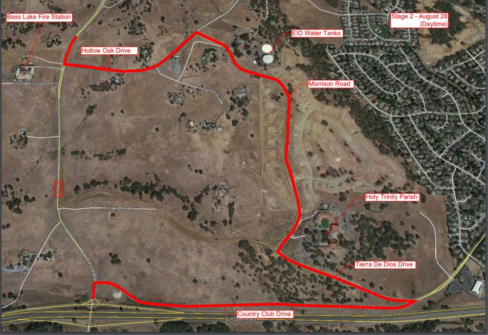
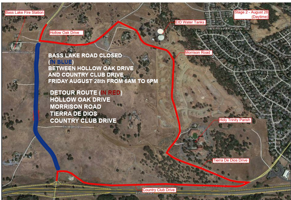
The first press release was to inform residents that a new detour will be in effect Friday morning August 28th beginning at 6AM. The new detour will route traffic on Bass Lake Road onto Hollow Oak Drive, to the NEW Morrison Road, taking drivers to Tierra de Dios Drive, where the detour will end at Country Club Drive. This Detour will last until the evening of Friday August 28th at 6PM, for a total of 12 hours.
The 12 hour detour will allow construction work to finish paving the new Bass Lake Road alignment. When the detour ends at 6PM, there will normal two way traffic on Bass Lake Road from the US50 Bass Lake Road Interchange in the south, all they way to Green Valley Road in the north.
August 28th 6AM to 6PM BASS LAKE ROAD CLOSED Image Courtesy of El Dorado County
August 28th 6AM – 6 PM Bass Lake Road CLOSED – in Blue DETOUR Route in Red
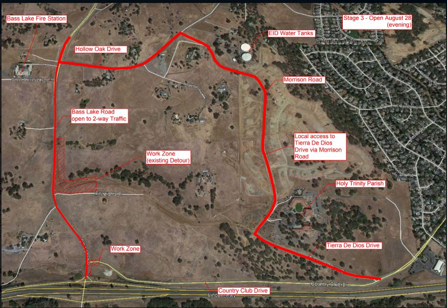
Country Club Drive DETOUR FRIDAY AUG 28th 6PM to SEPT 14th
The Second Press Release informed residents that after the 12 hour paving detour on Bass Lake Road is completed at 6PM on Friday August 28th, resulting in Bass Lake Road being open to two way traffic, that Country Club Drive from Bass Lake Road east to Tierra De Dios Drive will close through September 14th. The new detour route will have drivers on Country Club Drive travel on Tierra De Dios Drive to the NEW Morrison Road, taking drivers to Hollow Oak Drive, and back down to Bass Lake Road near El Dorado Hills Fire Station 86.
This Detour will allow construction on the new Country Club Drive road segment to be completed, along with demolition of the temporary detour road motorists have been using since May 1, 2020.
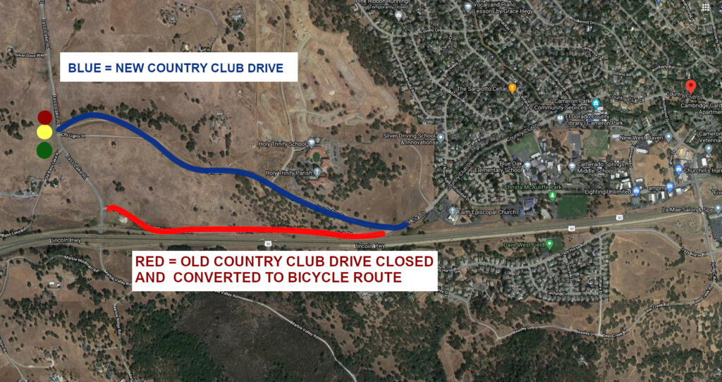
The existing Country Club Drive road segment between Bass Lake Road at US50 and Tierra De Dios Drive will be converted to a bicycle route, and closed to vehicles.
Motorists traveling on Country Club Drive that wish to use either the Bass Lake Road – US50 Interchange, or to travel north on Bass Lake Road will be required to use the Tierra De Dios-Morrison-Hollow Oak detour.
August 28th 6PM – Country Club Drive CLOSED between Bass Lake Road and Tierra De Dios Drive Image Courtesy of El Dorado County
EVENING of August 28th 6PM – County Club Drive closed between Bass Lake Road at US50 and Tierra De Dios Drive Access to Bass Lake Road and US50 for motorists on the RED Detour route. On September 14th.
In the September and October editions of the Bass Lake Bulletin, Kathy and I have offered a look at the past, present, and future conditions of Bass Lake Road.
When we built our home here in 1995, the developer disclosed to us that Bass Lake Road was going to be “re-aligned” in the next two years. That “re-aligned” road would be the still pending Silver Springs Parkway – whose planning began in the 1980s, and is still not completed in 2019. The 80’s, 90’s, 2000’s and the 2010’s have come and gone. It has now been four decades and it is expected to be constructed in 2020, which will be the fifth decade.
Bass Lake Road in 1995 was rather ‘suspect’ in terms of road conditions for what had been approved and the additional projects being considered. I feel that I might even be a bit generous with that description.
But, not putting a lot of faith in the promise of a housing developer’s sales team in a “new Bass Lake Road”, I began to do some homework on what was being planned for the area where we wanted to build our home. I looked for what I could find regarding future schools, parks, roads, shopping and other residential developments.
What was known in 1995
Checking for future projects for the Bass Lake area was difficult to complete in those old dial-up modem days. In fact, most information was really only available from the County Planning Department in Placerville and you had to see those documents in person. Some information was available from the school districts, specifically, the Rescue Union School District, as they were preparing to build Pleasant Grove Middle School.
At that time El Dorado Union High School District was also considering purchasing property next to Pleasant Grove Middle School so some information about the future around Bass Lake Road could be found.
We understood from the 1988 El Dorado Hills Specific Plan (Serrano and Town Center), that Bass Lake Road from Hollow Oak (then Stone Hill Road) was going to eventually get a new alignment to the west. It would feature a connection with Serrano Parkway which in 1995, hadn’t been finished yet and stopped at the Serrano Country Club entrance at Greenview Drive. Also, the final alignment of this section of Bass Lake Road was still being decided by the designs of the Bass Lake Hills Specific Plan.
The 1991 Bass Lake Road Study Area Environmental Impact Report (which was the base environmental review document for what would become the 1996 Bass Lake Hills Specific Plan) and the Final Environmental Impact Report for the 1988 El Dorado Hills Specific Plan indicated that by 2010 Bass Lake Road would need to be a divided four lane arterial road. In fact, I’ve seen one 1986 era document that had considered Bass Lake Road as a six lane roadway!
What about Bass Lake?
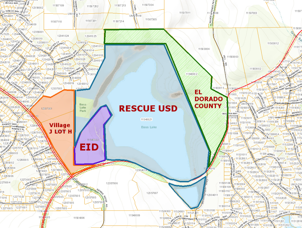
Bass Lake itself was identified in the 1988 EDHSP as “Village R” intended to remain zoned open space recreational in perpetuity. The 41 acres on the northeast side of the lake, now owned by El Dorado County, in 1988 was privately owned and preliminary plans were considered for townhomes or condominiums on the property. In 1999, the County began efforts to trade a 16-acre County owned commercial property in Cameron Park for the privately owned 41 acres at Bass Lake.
Bass Lake Parcels 2016. Since that time the EDH CSD has purchased the RUSD property, is in the process of purchasing the EID property, and is in negotiations with El Dorado County for their 41 acre property. 12.5 acres of the southern-most LOT H property is owed to the EDH CSD by Serrano Associates as a parkland dedication.
Developments in the Bass Lake Area 1995
Twenty-five years ago, the County was either in the process of planning or had approved major residential developments around Bass Lake: Serrano El Dorado, Bridlewood Canyon (already under construction in the late 1980s), Bass Lake Villages – The Hills of El Dorado, and Woodridge, Woodleigh Lane developments, Bass Lake Estates, Sierra Crossing, Silver Springs, Travois, and Emerald Meadows.
Serrano Villages in the Bass Lake Area were residential, although Village J5 was intended to provide a shopping center on both sides of the future Sienna Ridge Road. This was later downscaled in scope to the current version of the Sienna Ridge Shopping Center with the balance of the J5 commercial property on the northeast side of Sienna Ridge Road rezoned to residential and added to Village J6 in 2017.
Our current District 1 Planning Commissioner Jon Vegna asked for turn pockets in 2017 on Bass Lake Road when the rezone and revised commercial project at J5 was approved. He didn’t receive enough support from the rest of the Planning Commission or County Planning Staff. This was a common sense consideration by Commissioner Vegna, but turn pockets and left turn lanes were not deemed warranted by the El Dorado County Transportation Department (DOT) or County Planners. Commissioner Vegna was equally puzzled that a left turn lane on northbound Bass Lake Road was approved for the El Dorado Irrigation District maintenance yard on Bass Lake Road as part of the Serrano Village J5 Commercial redesign in 2017- without a merited traffic warrant.
A left turn lane was considered for the Bridlewood Canyon entrance for southbound Bass Lake Road at Bridlewood Drive in the late 1980’s when the Bridlewood Canyon project was in the design phase. However, the left turn lane planning consideration was rejected as not warranted.
During the approvals phase of the Woodridge residential project, a right turn lane was originally intended – however, the County traded the right turn lane on northbound Bass Lake Road for a left turn lane on southbound Bass Lake Road. Common sense in regards to traffic safety would have included both turn lanes.
The Serrano J7 Village, at the Bass Lake Overflow next to Bridlewood Canyon, at one point was considered for commercial development. There were signs posted along Bass Lake Road in the late 1990’s advertising the site as being available for commercial development. It was also identified in the 1988 EDHSP as a potential site for an El Dorado Hills Fire Department Station or, alternatively, an El Dorado County Sheriff’s Department sub-station/office.
How Bass Lake Road was going to be improved
Bass Lake residents, both existing and new, had been told that based on the County’s approved development plans that a four lane Bass Lake Road was on the way as mitigation for the thousands of planned and approved medium and high density homes. Every subsequent project in the area has been approved based on the concept that a four lane Bass Lake Road alignment was required (but not *conditioned*) by these major projects. This has been the bedrock belief of the community for twenty-five years. Also, keep in mind that Bass Lake Road is one of only a handful of north-south connector roads between Green Valley Road and US50, and a safe, free-flow of traffic on Bass Lake Road is a major component of the County’s Roadway Network.
Change in plans
However, since the overall Serrano project was downscaled from the originally approved 6000 homes to around 4000 homes and the BLHSP project was downscaled by a few hundred homes, as well as the projected development on the north end of Bass Lake Road never materializing, those plans for a four lane Bass Lake Road have been deemed unnecessary.
In fact, the original design for the re-aligned Bass Lake Road – Silver Spring Parkway – was approved as a four lane divided roadway. It was built as a two-lane divided roadway, with a right of way for a future four-lane roadway – but that could potentially involve either removing the sidewalks, or eliminating the center divider. For a project that has taken four decades to plan and build, and still hasn’t been completed, no one expects that Silver Springs Parkway will ever be re-constructed as a four-lane divided road.
In 2016, with the BLHSP 1996 twenty year Development Agreement between El Dorado County and BL Road LLC expiring, the County and the developers worked on a new agreement that would trade parts of the previously approved Bass Lake Road improvements from US50 north to Serrano Parkway for an immediate fix of realigning Country Club Drive north on Bass Lake Road.
Included in this new concept was a signalized Country Club Drive – Bass Lake Road intersection, bike lanes and a park and ride lot. Gone was the previously designed divided four-lane Bass Lake Road. This resulted in the developers “loaning” advances to the TIM Fee program to get improvements constructed sooner and those “loans” to the TIM Fee program would result in repayments to the first developers by subsequent development projects in later phases. This was an innovative approach with an increased risk to the first phase developers and one of the results is the re-alignment of County Club Drive which is under construction now.
But this has also resulted in a 40 year Community Facilities District, otherwise known as Mello-Roos fees, to finance this infrastructure to be paid by property owners in the BLHSP area communities.
A final result of these 2016 changes removed three Bass Lake Road Projects from the twenty year Capital Improvement Program (CIP):
Bass Lake Road Improvements removed from the 2016 CIP
Bass Lake Frontage Improvements-Silver Springs Project No: 66115 Roadway improvements to the existing Bass Lake Road east of Silver Springs Parkway, including full width improvements, curb, gutter, sidewalk (on northwest side of Bass Lake Road only), slurry sealing the pavement and restriping. Utility work consists of water connections and relocation of several poles.
Bass Lake Frontage Improvements-Silver Springs Project No: 66115 El Dorado County 2015 CIP Book
Bass Lake Road Full Improvements – Phase 1A Project No: 66109 Bass Lake Road from US 50 to Hollow Oak Road: widen and reconstruct to two-lane divided road with 4-foot shoulders and pedestrian/bike paths. Phase 1A improvements of the Bass Lake Hills Specific Plan PFFP; full improvements to include development of 8-foot median, sidewalk and bike lane from Hollow Oak Road to US 50; median improvements only from Hollow Oak Road to Serrano Parkway. Phase 1B improvements in project GP166. Funding for sidewalks, signals, bike lanes, median landscaping and median irrigation to come from PFFP. The expenditure for FY’s 2011/2012 and 2012/2013 is advancement of the culvert under Bass Lake Road which is needed as part of the Hollow Oak Road Drainage Project (72369).
Bass Lake Road Full Improvements Phase 1A Project No: 66109 El Dorado County 2015 CIP Book
Bass Lake Road Widening – U.S. 50 to Silver Springs Parkway, Phase 1B Project No: GP166 Bass Lake Road from US 50 to Silver Springs Parkway: widen from two to four-lane divided roadway; includes curb, gutter, sidewalk, shoulders (4′ shoulder existing) for 2.4 miles (US 50 to Silver Springs Parkway). Phase 1B improvements of the Bass Lake Hills Specific Plan PFFP. See 66109 for Phase 1. This estimate includes improving the portion of Bass Lake Road from Serrano Parkway to approximately Madera Way from the substandard 2 lane existing road up to the 4 lane divided ultimate. The estimate also includes upgrading just north of Sienna Ridge to Silver Spring Pkwy to standard 2 lanes.
Bass Lake Road Widening – U.S. 50 to Silver Springs Parkway, Phase 1B Project No: GP166 El Dorado County 2015 CIP Book
2018: Four-Lane Bass Lake Road BACK in the 20-year CIP
In 2018, the DOT added a four lane configuration of Bass Lake Road from US50 north to Serrano Parkway as a new project back into the County’s twenty year Capital Improvement Program (CIP). However, the planning/environmental work, design, right of way acquisition, construction, environmental monitoring and actual funding (identified only as sourced to El Dorado Hills Zone 8 of the TIM Fee program) were scheduled to the years of 2028-2038 – ten to twenty years out.
2019: OFF again -Four-Lane Bass Lake Road removed from 20-year CIP
This year, less than a year after adding the Bass Lake Road four lane project, it was removed from the twenty year CIP in favor of the signalization project of the eastbound US50 Bass Lake Road off ramp, partly due to the vagaries of where the line for rural region vs. community region falls on a map. In this case, Bass Lake Road north of City Lights Drive (the new Country Club Drive intersection) is in a community region, while Bass Lake Road south of City Lights Drive to US50 is in a rural region and has a lower Level of Service (LOS) trigger for improvements – the rural region being LOS E and the Community Region trigger being LOS F.
No one questions the need for improvements to the Bass Lake Road US50 interchange since the afternoon traffic regularly backs up on the eastbound off ramp onto the US50 travel lanes. Nor does anyone question the need for improving the Country Club Drive and Bass Lake Road intersection, historically the worst performing intersection in the County’s roadway system.
Residents welcome these improvements which are long overdue even without the Bass Lake Hills residential projects which are now under construction and are providing the majority of the funding for these improvements.
Confusion reigns
However, constantly changing status of Bass Lake Road improvements in the County’s twenty-year CIP – four changes in four years – leave residents confused as to what the actual expectation of improvements to Bass Lake Road will be.
The difficulty lies in the fact that the County conditions projects to only meet the lowest acceptable traffic conditions, like getting a D minus grade and bragging that you passed the class. Sure, a passing grade, but nothing to shout about. So the County improves our roadways to “just good enough” and believes those improvements to eliminate roadway capacity and safety issues in terms of long-range planning will suffice.
According to the County’s traffic models it does, but the reality to residents is something else.
Bass Lake Road: Around the lake
The same conditions exist at the northern end of Bass Lake Road. From Serrano Parkway to just past Madera Way, the imminent 2020 construction of the Silver Springs Parkway connection is seen as the ultimate solution for our traffic concerns. And, indeed, eliminating the 25 MPH curve on Bass Lake Road will remove a major source of traffic collisions and fatal accidents which is an improvement that has been proposed for four decades.
So many intersections in close proximity
But neighbors still have concerns about the proximity
of the new Silver Springs Parkway and Bass Lake Road three way stop
intersection a few hundred feet from the Madera Way intersection which is only
a few hundred feet north of the Bridlewood Drive intersection.
Compounding this, Bridlewood Drive is less than 500 feet from the future Serrano Village J7 intersection at the curve along the Bass Lake Overflow, and 1100 feet from the new Whistling Way/Bass Lake Road intersection for Serrano Village J6. That is five intersections within 2800 feet.
Bass Lake Road intersections between Serrano Parkway and Woodleigh Lane
The DOT has concluded as part of the review of the Serrano Village J7 project that in conjunction with the lower number of residential homes from what was approved for the EDHSP, the BLHSP, the Silver Springs residential project, and the lack of other projected development in the area, that a four lane alignment of Bass Lake Road is not merited. Without the need for the four lane alignment in the expected life of the County General Plan, the DOT, which has right of ways for the four lane alignment that would bring Bass Lake Road almost to the Bridlewood Canyon Gatehouse, has determined that the road frontage improvements – curbs, gutters, sidewalks, etc. – as provided in the 1988 EDHSP for Villages J7 and J6, would not be required to be constructed at this time.
Instead they have opted to collect just road frontage
improvement fees to be held and used at an unidentified future time when a four
lane alignment of Bass Lake Road would be warranted.
But if there is no warrant for a four lane Bass Lake Road in the life of the County General Plan – if a four lane alignment will never be built – why not build those frontage improvements now? No other Serrano Village lacks those amenities, and it would improve traffic and pedestrian safety in our area.
BLAC has spoken with Parker Development/Serrano Associates many times in the past several years regarding these projects and many more times in the past few months. They have been very generous with their time and have been genuinely interested in our traffic concerns. They have always indicated to BLAC that they would provide any frontage improvements that are agreed to in both the EDHSP and their Development Agreement with El Dorado County. However, since the County won’t ask for the frontage improvements or determine the ultimate alignment of Bass Lake Road, they will instead contribute the road frontage improvement funds as required by the County.
In reviewing the Village J7 project at recent Planning Commission hearings, several planning commissioners questioned the existing conditions on Bass Lake Road. The DOT, hearing those concerns, asked Serrano Associates to pay for a new traffic study whose results were provided to the County at the end of September.
2019 September Traffic Study Results: LOS C and accident rate half of the County average
The Traffic Study stated that generally the conditions on Bass Lake Road between Serrano Parkway and Madera Way are at a LOS C and D and the reported accident rate is half that of the County average. Capacity improvements in a Community Region – and this is in the El Dorado Hills Community Region – are triggered by LOS F.
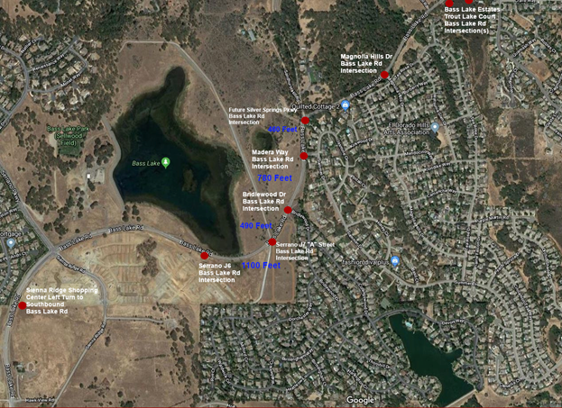
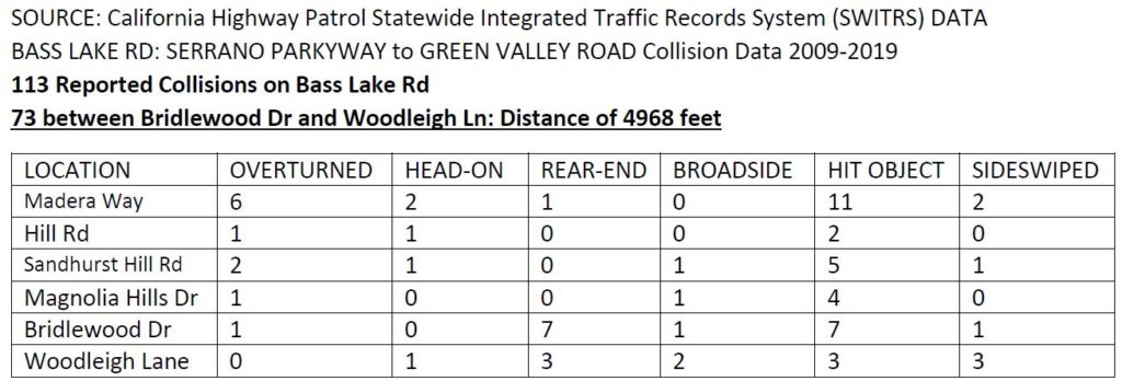
The BLAC Traffic Safety Committee (TSC) had pulled data from the CHP about collisions on Bass Lake Road between Serrano Parkway and Green Valley Road for the period of 2009 through May 2019. The data showed 113 reported collisions. Of those 113 collisions, 73 occurred between Bridlewood Drive and Woodleigh lane, about 64% of all the collisions occurring over a section of roadway less than 5000 feet long. If that accident rate is half the County average, then the County, in terms of road safety, really does have larger problems than Bass Lake Road.
CHP 2009- May 2019 Collision Data Bass Lake Rd between Serrano Pkwy and Woodleigh Ln
I received a hard copy of the traffic study results on September 30th and on that day I was visiting a neighbor in Bridlewood Canyon. After my visit, I waited for about two minutes for thirty-eight cars to pass (I counted) until I could safely make a left turn from Bridlewood Drive to southbound Bass Lake Road at 3:45PM.
The traffic study provided that the worst case stopped delay per vehicle on a minor street (Bridlewood Drive) is 22 seconds. The traffic studies are automated with equipment providing the raw data for study. My real world experience, like many residents, was decidedly different. Current conditions of LOS C and LOS D on Bass Lake Road between Serrano Parkway and Madera Way, in conjunction with the 2020 construction of the Silver Springs and Bass Lake Road intersection, indicate that no improvements will be warranted in the next 20 years.
In short, Bass Lake Road between Serrano Parkway and Madera Way, even through to Green Valley Road, is an adequate, safe roadway, per County standards.
The opening of the Sienna Ridge Shopping Center is considered in those calculations so the DOT believes it should have no impact on warranting additional improvements on Bass Lake Road.
Bass Lake Road north of Magnolia Hills Drive: No improvements planned
Lost in all of this data is that there are no improvements planned for Bass Lake Road from Magnolia Hills Drive to Green Valley Road with the exception being three new intersections:
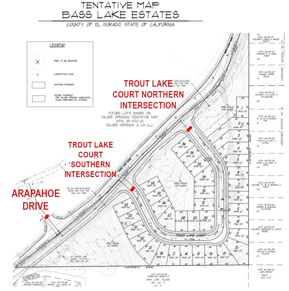
Intersection 1. A street intersection on the north side of Bass Lake Road for the Silver Springs residential project, Arapahoe Drive, at roughly the current Hill Road location.
Intersections 2 & 3. Additionally, there will be two more intersections on the south side of Bass Lake Road for the thirty-six home Bass Lake Estates residential project. Trout Lake Court (which is really a circle) will be constructed just north of Tea Rose Court and south of Woodleigh Lane.
Three new intersections, all located within a few hundred feet on opposite sides of Bass Lake Road between Magnolia Hills Drive and Woodleigh Lane, will result in five intersections on about 4300 feet of Bass Lake Road on a hill and on a slight curve.
Three new Bass Lake Rd intersections between Magnolia Hills Dr and Woodleigh Ln
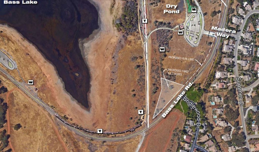
False Start: Transportation Maintenance Yard at Bass Lake
Earlier this year, the County Department of Transportation had asked the Board of Supervisors for direction on building a maintenance yard on the south side of Bass Lake directly across from Bridlewood Drive and the planned Serrano Village J7 at the Bass Lake Overflow. That would have added a third intersection within 470 feet on a curve. Residents, concerned 1) about the inconsistent land use of a maintenance yard across the road from residential developments, and 2) with its impacts on the natural environment of Bass Lake, were alarmed, to put it politely. Due in part to those resident concerns, the planned maintenance yard is being considered for a location behind El Dorado Hills Fire Station 86 on Bass Lake Road instead.
January 2019 – Proposed El Dorado County Transportation Department 1.2 acre Maintenance Yard at Bass Lake, opposite Bridlewood Drive
Bass Lake Road Improvements to be provided by future development projects: Where?
Asked when residents might see improvements to Bass Lake Road, County Planners indicated that future improvements would be warranted by, and paid for by, undefined future developments. To most residents’ thinking, there is not enough remaining land that could be developed in a scale large enough to provide these improvements.
Bass Lake Area approved and proposed development
El Dorado County through its land use authority has approved and conditioned the development of thousands of medium and high-density homes in the Bass Lake Area. Through its Transportation and Planning Departments, the County maintains that Bass Lake Road as configured, and with planned improvements at the US50 interchange, the new Country Club Drive intersection, and the future Silver Springs Parkway intersection, is an adequate roadway for existing and future conditions in terms of capacity and safety. Residents, for the most part disagree. Residents are concerned that when the Sienna Ridge Shopping Center opens, that the increase in traffic volume from this project, along with the increase in traffic volume from the new Serrano J6 and J7 villages, and the Silver Springs residential project, will negatively impact the quality of life in our area.
Walk or ride a bicycle? Not safely
Pedestrian and bicycle facilities are planned to be completed from Serrano Parkway south to US50. There are no pedestrian or bicycle facilities on Bass Lake Road between Serrano Parkway and Green Valley Road. They will be included in the Silver Springs Parkway project but a gap remains from Silver Springs to the Sienna Ridge Shopping Center. Also, there are no pedestrian or bicycle facilities from the planned Silver Springs intersection to Green Valley Road. The exceptions: Sidewalks from Green Valley Road to Parkdale Lane on the east side of Bass Lake Road, sidewalks from Green Valley Road to Foxmore Lane on the west side of Bass Lake Road, and a sidewalk between Green Valley Elementary and Lambeth Drive – but no bicycle facilities.
What about the Bass Lake Community Park?
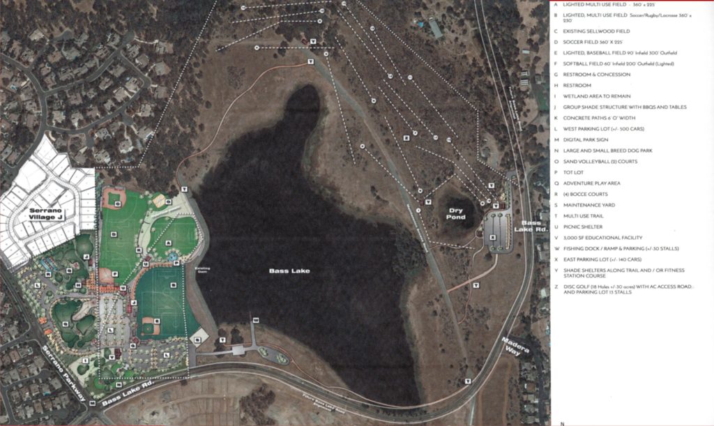
Another consideration is the impact of the proposed Bass Lake Regional Park. The El Dorado Hills Community Services District (EDH CSD) is conducting outreach, and seeking funding for a two-hundred – plus acre park that will have entrances on Serrano Parkway, Bass Lake Road at roughly the EID Maintenance Yard driveway, and at the new Silver Springs Parkway – Bass Lake Road intersection. Conceptual plans call for 500-plus parking spaces on the west side near Serrano Parkway, and 140 parking spaces on the east side near Madera Way. Vehicle traffic for major events – with over six-hundred parking spaces, is comparable to having another subdivision added, with vehicle trips for major events occurring in a compressed time frame.
EDH CSD Conceptual Bass Lake Community Park
The EDH CSD is in the business of building and operating park and recreation facilities – they don’t build roads. The EDH CSD is envisioning a possible $15 million park project, for which they will have to find funding. Signalizing one intersection can cost upwards of $1 million – that’s over six percent of the entire park budget.
The Future: The Magic Eight Ball Says “Outlook not so good”
When a link to our petition for traffic and safety improvements for Bass Lake Road was shared in a public El Dorado County Facebook Group, a County Transportation Department employee shared details of the as yet unreleased September traffic study as resulting in LOS C. The employee mockingly derided concerned residents as ‘chicken littles’ and offered the advice that residents in the area shouldn’t complain about the road when we “…drive your $60k Mercedes off Bass Lake Road”. This sort of treatment of residents’ concerns, although only from one individual employee, demonstrates why residents are alarmed when our concerns and questions are perceived to be rejected out of hand.
So it seems that there will be no improvements to the northern section of Bass Lake Road with the exception of the Silver Springs Parkway connection. The only changes will be increased impacts through already approved developments that have no significant conditions to mitigate their impacts to Bass Lake Road itself. Bass Lake Road will need to reach LOS F before improvements can be realized.
If residents feel that these traffic and pedestrian safety concerns are valid, they should respectfully contact the County Board of Supervisors, the County Planning and Building Services Department, and the County Transportation Department. Additionally, consider reviewing and supporting residents’ Bass Lake Road Traffic & Pedestrian Safety Petition.
This is our community; the opportunity is now – make your concerns heard.

 Loading...